A walk from Carlisle to Tweedbank
The Waverley Line
In late June 2023, I spent a week walking from Carlisle in England to Tweedbank in Scotland following, as closely as possible, the 63 mile course of the much-missed Waverley Line. I then completed my journey with a train trip from Tweedbank to Edinburgh along the 35 miles of the line reopened in 2015.

The Waverley Line was constructed south from Edinburgh through the beautiful countryside of Midlothian and the Scottish Borders to Carlisle. It was built by the North British Railway in two stages: Edinburgh to Hawick in 1849 and Hawick to Carlisle in 1862. The name comes from the association with Sir Walter Scott (1771-1832) who lived in the area that the railway later passed through and used it as a setting for his Waverley novels.

The whole 98 mile line was a casualty of the Beeching Report and closed in 1969 in spite of serious protests. However, after a hard-fought battle, the most-northerly section from Edinburgh to Tweedbank (a brand new station between Melrose and Galashiels) reopened in September 2015. The new line is now known as the Borders Railway and there are tentative plans to extend it on to Hawick and even back to Carlisle. There is an active campaign group lobbying for this and their website, campaignforbordersrail.org., is certainly worth a look.
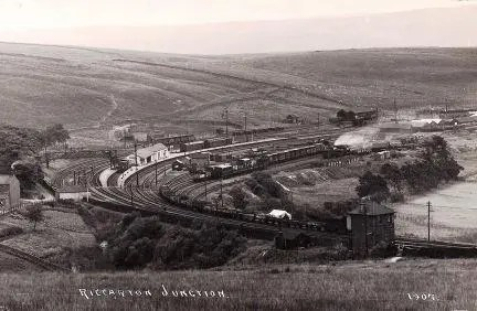
From Carlisle to Edinburgh the old line featured over 35 stations. The story of each one of them, along with a detailed history of the line itself can be found on the incredible “Disused Stations” website – (example – Port Carlisle Junction) I have provided links to all the relevant pages on “Disused Stations” in the description of my walks.

The Plan
My plan was to travel to Carlisle on a Monday morning and then walk to Longtown the same afternoon. On the Tuesday I would head to Newcastleton, and then cover the longest and most isolated section to Hawick on Wednesday. Thursday would then see me reaching Newton St Boswells, with just the short section to Tweedbank left for Friday. After catching an early afternoon train from Tweedbank to Edinburgh, I would spend the weekend in the Scottish Capital.
The Walks
Click on the links….
#1 – Carlisle to Longtown (Monday)
#2 – Longtown to Newcastleton (Tuesday)
#3 – Newcastleton to Hawick (Wednesday)
#4 – Hawick to Newtown St. Boswells (Thursday)
#5 – Newtown St. Boswells to Tweedbank/Edinburgh (Friday)
Preparation
I planned to walk alone.
I booked accommodation for the four nights well in advance. I knew that the availability of rooms in Longtown, Newcastleton and even Hawick was very limited.
Knowing there would be no services at all along my three longest routes, I planned to purchase lunch before setting out each day and carry up to 2 litres of water with me.
In total I would be carrying about 7-8kg in my Lowe Walkabout 25. Given the area and expected weather, I made sure everything was waterproofed.
As I expected to be walking on relatively hard surfaces for most of the time, I planned to wear my Salomon X Ultra walking shoes.
Whilst all of the track bed between Carlisle and Tweedbank is clearly discernible on maps, not all of it is fit for through walking. Happily, a lot of the most scenic stretch from Newcastleton to Hawick can be followed, with one or two diversions, although some care is needed.
South of Newcastleton much of the old railway lies in England and is often on private land where no right of way can be assumed. Some sections have been turned into footpaths and can be followed, but other parts need to be bypassed.
North of Hawick, things are easier because Scottish “right to roam” means there are fewer issues with crossing private land. Nevertheless, caution is still needed to avoid unexpected obstacles; a long stretch of track bed might exist as a local dog walking path, but then be blocked by impenetrable undergrowth or a missing river crossing further on.
I worked with detailed mapping (Canmore was particularly useful, as was Plotaroute) in advance of my trip to try to create an enjoyable walking route based on the Waverley Line that would stay close to the old railway but try not to get too obsessed with it.
I particularly wanted to avoid spending too much time hacking my way through nettles in dark woods just for the sake of following the old route too exactly. Nevertheless, I aimed to capture the spirit of the line and planned to include visits to as many of the old station sites as possible.
To supplement my OS Maps, I used MAPS.ME on my iPhone to navigate. The app aids wayfinding even when the phone is in airplane mode.
My overall impressions, conclusions and advice are included at the end of #5.
Maps of the route
The route I took can be followed using maps (embedded in the text) that I created using Openstreetmap.org. I have adapted the original maps by showing them in black & white. I have then added colours to illustrate my route and the path of the old railway.
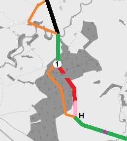
- The sections of track bed that I used as part of my Carlisle to Tweedbank journey are shown in Green.
- Purple denotes an issue (blocked path etc.) referred to in the text.
- Where I believed that the track bed could not be used as part of my through route, I have shown it in Red, although certain sections that are known to no longer exist (dismantled bridges etc..) are shown as gaps.
- In Scotland, some of the paths I encountered that might be used for short one way walks are shown in Pink.
- The short sections of the Waverley Line which still have track are shown in Black, as are any other operational railways in the area.
- My route, on paths and roads, bypassing the old track bed is shown in Orange.
- The approximate positions of stations are shown by numbers.
- Points of interest mentioned in the text are referred to by letters.
Notes
- All maps are included as background only and should not be depended on for navigation.
- In the route descriptions the terms “north” and “south” generally refer to the direction towards Edinburgh and Carlisle respectively and not to absolute points of the compass.
- Whilst I believe all the information is broadly correct as of July 2023, no attempt will be made to keep any of it updated. Nevertheless, any corrections, especially the spellings of place names, will be gratefully received and acknowledged.
- To the best of my knowledge, all my photographs of former railway buildings that are now being used as private dwellings were taken from public roads; where this was not possible photographs have not been included. (Multiple photographs of all the stations in their present condition can be viewed on Disused Stations).
Begin….
