“Mow Cop and Scholar Green….”
Mow Cop & Scholar Green (1848-1964), one of two stations on the list in Cheshire, was opened by the North Staffordshire Railway. Today the line forms part of the main electrified Manchester to Euston (via Stoke) line. As well as local services, two 125mph Pendolino expresses hurtle past each hour taking just over two hours to get from London Euston to Manchester Piccadilly.
The line itself, one of the country’s busiest, was never up for closure. The station was closed to reduce the number of unnecessary stops and try to concentrate traffic on faster services. There were many examples of this around Britain, and often comparatively larger places on busy main lines lost their services whilst smaller places on secondary routes kept theirs.
Location
The X on the map shows the approximate location of the station in relation to the current British railway network. The nearest open station is Kidsgrove around 2.8 miles away.

The red dot on the map below shows the approximate location of the station in relation to the local area.

Services: Past, Present & Future?
In 1962 the station was served mainly by the stopping service that ran between Stoke and Manchester. The trains were roughly hourly and took 50 minutes to get to Piccadilly and around 16 minutes to reach Stoke. The journey into Stoke now takes around 50 minutes by bus and train via Kidsgrove.
There have been plenty of examples of reopening lost stations on existing passenger lines all over the country. If there is resurgent demand (local housing developments etc.) and the stop can easily be slotted into the schedule, it is relatively easy to do.
Nevertheless, as far as I know, there is no plan to do that here yet.
Station Site
The station site was easy to find next to the level crossing on Drumber Lane. The platforms used to be split either side of the crossing. The up (towards London) platform used to be on the south side; the down platform used to be on the north side. There used to be a signal box opposite the up platforms too, but it was removed (long after the station closed) and is now preserved privately in the village.

The level crossing itself is automatic, remotely controlled and CCTV monitored. The line is extremely busy with trains; in the 30 minutes we were there five trains passed by. Fortunately, Drumber Lane is not so busy with cars.
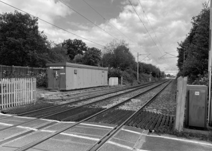
Nothing seems to be left of the station now. Apart from a little extra space beside the tracks, there is little evidence that trains ever stopped here.

Surrounding Area
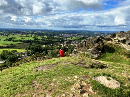
The station was built a mile away from the village of Mow Cop. The village is located to the east of the line on the side of a hill; Mow Cop Castle, its most prominent feature, is at the top and is clearly visible from the level crossing. The “Killer Mile” distance from the crossing to the castle has become a challenging short race for both runners and cyclists.

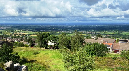
As we climbed towards Mow Cop, we noticed that the road changed its name to “Station Road” and then, as we neared the summit, changed again to “Top Station Road”. The pub close to the top, and almost a mile from the crossing, is now named “Cheshire View” but for many years it was the Station Inn.
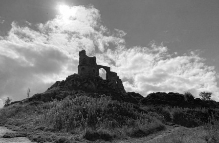
Mow Cop Castle itself was built in 1754 and is a folly: it was constructed to resemble a much older structure. Randle Wilbraham, of nearby Rode Hall, had it built for use as a summer house. Today it is derelict and in the care of the National Trust.

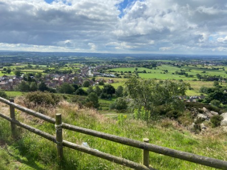
The views in all directions from the top were magnificent. Standing here we were just about on the border between Cheshire and Staffordshire, and by extension at the boundary between the Midlands and the North West.
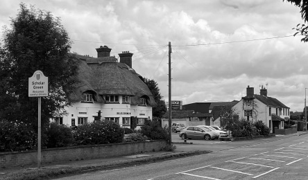
The reference to Scholar Green was added to the Mow Cop name around fifty years after the station first opened. Retracing our route back down to the crossing, we went across and turned south along, yet another, Station Road. After passing by a busy marina on the Macclesfield Canal we came to the centre of the village.
Lying completely on the west side of the railway line, Scholar Green was, in contrast to its hilltop neighbour, built completely on the flat. It seemed like an agreeable place to live; there was a lot of pleasant-looking housing, a busy convenience store and a few pubs.
One of the pubs was built, like Mow Cop Castle had been, to look a lot older than it was. Constructed in “Vernacular Revival” style in 1936 the “Bleeding Wolf” had an impressive, thatched roof. It is grade two listed.