West Reservoir
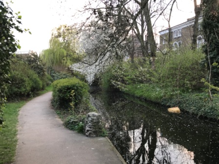
Now we followed the New River Path as it skirted the north rim of the West Reservoir. At first glance it seemed that the New River itself, separated once again by a little embankment, was continuing on with us after all.

However, appearances can be deceptive: the water we were seeing here was ornamental rather than functional.

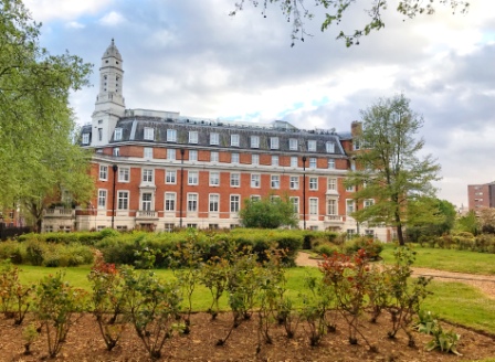
This lake, unlike its eastern sister, no longer functions as a water storage facility. Instead it is now used for yachting, canoeing and even open water swimming.

The beautiful old 1930s waterworks that sits on its western edge has now been turned into a water sports centre.


The building is well worth popping in to. The former machinery hall is now used as a cafe, function room and lake viewing area. Some of the old equipment remains in situ and it is interesting to wander around looking at all the old pumps and dials.

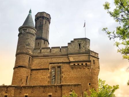
Back on the path, we followed the channel as it headed out past the entrance to the water sports centre and then we watched as it ended abruptly at Green Lanes. There, standing across the road from us, was yet another New River Company creation : the “castle”.

Castles and Parks
The “castle” is actually just another 19th century pumping station, but it is disguised as a fortress to make it look a bit more interesting. It was once threatened with demolition but it is now grade 2 listed. It has been refurbished and is currently being used as a climbing activity centre.
Although the New River was only finally truncated back at the East Reservoir in 1946, the last section we were now walking over was progressively piped underground between the 1860s and 1890s. By the turn of the 20th century almost nothing was visible on the surface south of the West Reservoir.
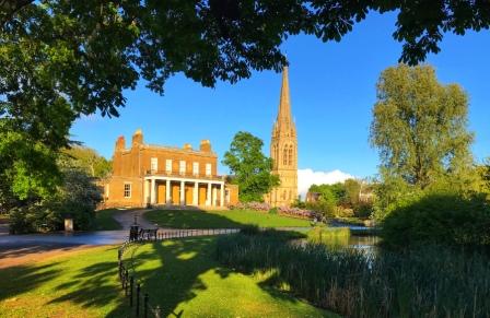
We headed south along Green Lanes and a short walk brought us to Clissold Park. We entered the park and continued to follow the New River Path as it retraced the loop the original 1613 waterway once took through the park.

Just before Clissold Mansion, now utilised as a café, there was a restored ornamental section of “New River” together with two attractive modern footbridges.

They had both been engraved with the Latin motto of the New River Company: Et plui super unam civitatem” (“And I rained upon one city”). It was a nice touch.
Hidden River
We left the park and walked along its southern edge before crossing the road in front of the interesting-looking “New River Café”. It was encouraging to see that, despite there being no water to see, the sign posts were still continuing to point the way.
At the back of the café we turned into Aden Passage where the space left by the old waterway had been filled by a series of allotments. There were quite a few people tending to their plants and crops as we walked past. The soil must be good here, we thought.

Next we turned into Petherton Road and it was immediately obvious that the New River had once flowed down the centre of this long avenue. A section of road had been built either side of the water and large Victorian houses lined the whole thing. The long-since-vanished water had been replaced by an attractive garden with trees.

At the bottom of Petherton Road we emerged onto St Pauls Road. We crossed that road and then walked into the part of the New River that I first encountered 5 years ago.
New River Walk
Between here and Essex Road, Islington Council have opened a little section of the New River as a kind of linear park. They have named it “New River Walk” a name that it is easily confused with “New River Path”, of which it is, of course, also a part.

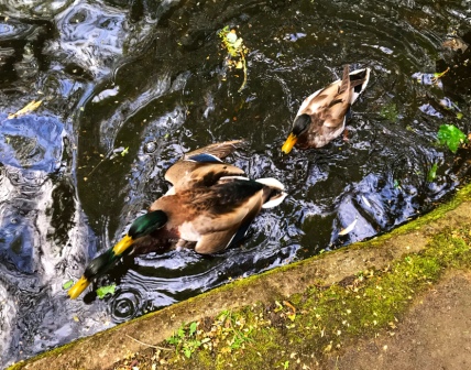
There was plenty of ornamental water here. The water twisted and turned in a way the original New River would never have done past a collection of trees and shrubs and a series of rockeries. It might not have been authentic but it was certainly very pleasant.

New River walk certainly seemed popular and there were quite a lot of people out jogging, walking their dogs or just sitting on benches enjoying the pleasant ambience.
Towards the end of New River Walk was a small stone building which was apparently once a watchman’s hut. The ornamental water section ended just behind the hut. It was the last little bit of water on the surface that we would encounter on the trip.
Myddleton Arms
As we emerged from New River Walk, we saw the Myddleton* Arms pub on the left and decided to pop in for a pint.

I was a little disappointed not to see a portrait of Sir Hugh Myddelton on the pub sign; the sign featured the palm of a hand instead. Whilst I was ordering my pint I asked the barman about the sign. He asked if I had heard of the New River and when I told him that I had, he said “well Myddelton opened it by turning on the tap with his hand”.

He added “and he was into gloves as well” before concluding “It is all a bit weird”. Weird or not, the Myddleton Arms was a nice place for a drink, it was pleasantly refurbished inside with a nice cosy garden out the back.
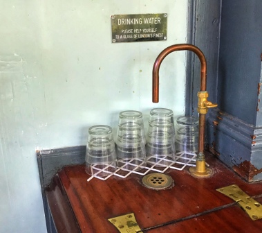
As we were leaving, I noticed that there was a tap for drinking water next to the bar. A sign above it said “Please help yourself to a glass of London’s finest”. I wondered how many customers understood the connection with the person the pub is named after.
Spontaneous City
From the Myddleton Arms we continued to follow the route of the New River into Astey’s Row. There was no water here but it was easy to imagine the river flowing through what is now a linear rock garden. Eventually we entered Essex Road at an angle and there, as we walked past busy restaurants and shops, it was a little more difficult to imagine the New River. Apparently it was always in tunnel there anyway.

Soon we headed off to the left into Colebrooke Row where once again a garden (Duncan Terrace Gardens) had been created in the centre of a street where the New River once used to flow.
Towards the southern end of the gardens we came across “Spontaneous City”: a conservation project which has led to about 300 bird boxes being nailed to a tree.

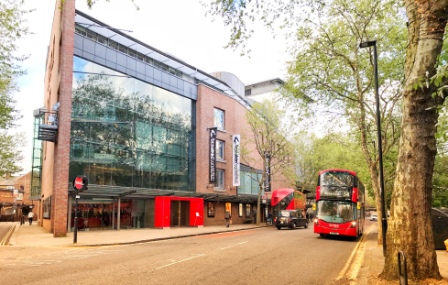
Almost at the end of our walk now, we crossed City Road and Goswell Road in quick succession and then made a little detour around Owen’s Field to avoid a modern building blocking the course of the old waterway. We finally emerged onto Rosebury Avenue and continued walking until we were standing in front of Saddler’s Wells theatre.
New River Head
The original Saddler’s Wells was opened in 1683 not so long after the New River was completed. The current 1998 building is, amazingly, the sixth to occupy the same site. The waterway flowed right past the entrance and the theatre actually used to use some of its water for its “Aquatic” performances. Today the modern Saddler’s Wells is a world-renowned centre for dance.
Just to the left of the theatre (looking north) would have been the final terminus of the waterway: New River Head. Here stood an oak-lined reservoir, 200 feet in diameter, known as the Round Pond.
From here the water was distributed around the city, again often using gravity, in wooden pipes. It was here in 1613 that the opening ceremony was held. It was attended by the Lord Mayor, Aldermen of the City of London and, of course, Sir Hugh Myddelton himself.

In order to get a closer look we went up the side of Saddler’s Wells and then down Myddelton Passage. The New River Path finally ended at a little gate that opened out into a viewing platform over the whole site. The platform contained lots of boards with detailed explanations of the New River and its role in the supply of water to London. It was all very well done.

We were now looking south. The Round Pond would have been straight ahead of us. An informative display showed us how the scene would have looked in 1752. The white building we could see on the left of the display was Saddler’s Wells and the New River was behind it.
“And I rained on one city”
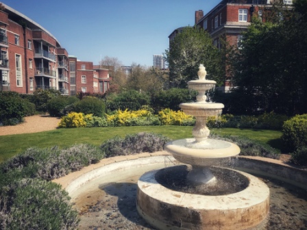
Having finished with the viewing platform, we popped next door into the gardens of the New River Head apartment block. A fountain in the centre stood pretty much where the Round Pond would have been.
In 1613 the New River was an immediate success. The New River Company itself was incorporated in 1619 with Myddelton as first governor. It prospered and a headquarters, the River House, was built at the edge of the pond. It featured a lovely oak-panelled boardroom.

The New River Head itself grew as the need for more water grew. The basin was extended and eventually another outer reservoir was constructed. Although the growth of London meant that the New River came to supply a smaller percentage of the city’s water as time went on, the company still managed to last almost 300 years.
The New River Company was finally wound up in 1903 when it was merged into the publicly-owned Metropolitan Water Board responsible for all London’s water supply. Significantly, the board kept the Latin logo of the old company and based itself at the New River Head.
In the 1920s it opened a large Headquarters on the site. The new building actually incorporated the oak boardroom from the old head office. The Metropolitan Water Board building and the slightly later 1930s laboratory building have now been turned into the luxury apartments whose garden we were now standing in.
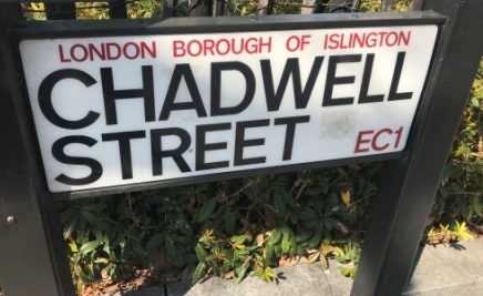
We left the gardens and went for a little walk around the surrounding area. The streets near the New River Head were all originally owned and developed by the New River Company. They all have names like Chadwell, Amwell and Myddleton that refer to places and people connected with the waterway itself.
The area is quite attractive and worth a good walk around. Not to be missed is the interesting Fig Tree on Amwell Street. The tree is directly opposite the main entrance to the modern Thames Water site.

In 1989 responsibility for London’s water passed to Thames Water and although the HQ of the company is no longer at the New River Head, it still has a big presence at the site. One of the entry shafts for London’s ring main is located here, and it is amazing to think that this area has continued to play a key role in London’s water supply for over 400 years.
Cholera
By way of creating a postscript to our little trip, we headed off to Soho for a final drink at another pub.
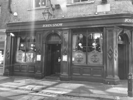
The John Snow pub on Broadwick Steet is named for the physicist who first associated the disease Cholera with dirty water. Snow made his discoveries back in the 1850s at a time when the rapid growth of the city had lead to much of the drinking water being obtained, once again, from the Thames.
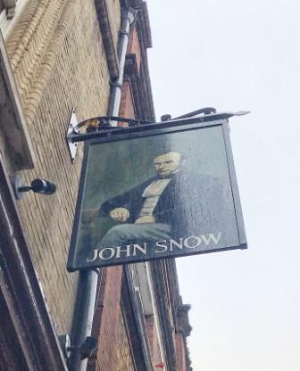
Snow worked out that a Cholera epidemic in Soho was connected to supply from one particular water pump, located outside the current pub, in Broad (now Broadwick) Street in the heart of the district.

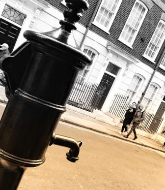
By ordering the handle of the pump to be removed he saw the epidemic abate and proved the hitherto unknown connection between dirty water and the disease. There is now a water pump replica outside the pub. It has no handle.
Snow’s findings led to legislation that finally guaranteed the purity of London’s drinking water. Analysis had also shown that in the places where drinking water was still sourced from the New River, the incidence of Cholera had been rare. The standard of water from the New River was thus held up as a benchmark for London.

As we sat in the pub we raised a glass of beer to the memory not just of John Snow but also of Sir Hugh Myddelton and his remarkable New River project.
New River by Rail
The New River Path is easily accessible by train.
The walk can be divided up into 4 parts that have a railway station within easy reach at each end. The parts, roughly 7 miles each, can be tackled by themselves or combined to make a longer walk. The directions below are for walking from north to south.
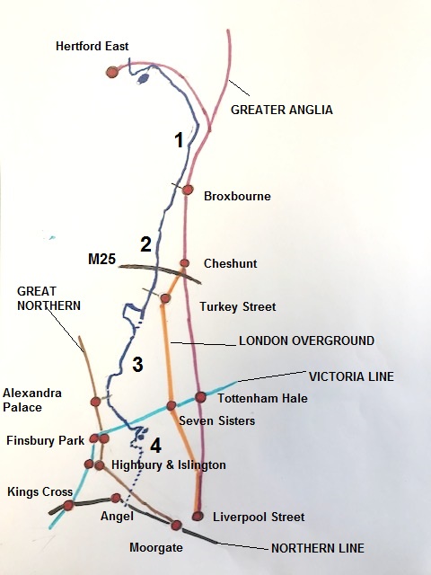
1) Hertford East – Broxbourne
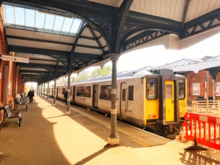
Hertford East is at the end of a branch line from Broxbourne. It is served every 30 minutes by Greater Anglia trains from Liverpool St. (approx 50 min).
At Hertford – Exit the station under the brick canopy and turn right. Follow Mead Lane for about 10-15 minutes (passing a new housing development and an industrial estate) until it narrows into a gravel path and heads off to the left. Follow it until it forks and then take the right hand path. The New Gauge Building, the start of the New River, can be seen in the distance. It is about a 20-25 minute walk from the station.
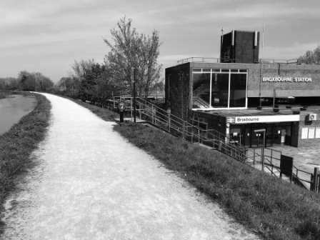
Broxbourne (30 min from London) is served by the Hertford East trains as well as more services heading down the main line towards Cambridge. A very useful connection with London Underground’s Victoria Line is available at Tottenham Hale.
At Broxbourne – the New River passes the station on an embankment. There is a staircase linking the path with the station car park.
Note that both Hertford and Broxbourne are outside London’s fare zone 6.
2) Broxbourne – Turkey Street
On reaching the sign for the Thames Water Maidens Brook Depot, turn left off the New River path. This is Turkey Street. Follow it, crossing the busy A10 via a subway, for about 10-15 minutes to reach Turkey Street Station which is on the left hand side after the railway overbridge.
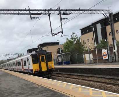
Turkey Street is on the London Overground “Southbury Loop” line between Liverpool St. and Cheshunt. There are usually two trains an hour with a journey time into Liverpool St. of around 40 minutes. Another useful connection with the Victoria Line is available at Seven Sisters.
Turkey Street is in zone 6.
3) Turkey Street – Alexandra Palace
After passing through Nightingale Gardens, Alexandra Palace Station is clearly visible from the New River Path. Turn off the path here and walk down St Michael’s Terrace to reach it.
Alexandra Palace is on the Great Northern Line from Hertford North / Welwyn Garden City to Moorgate. There are usually 6 trains an hour in each direction. Finsbury Park, with connections to the Piccadilly and Victoria Lines, is about 8 minutes to the south. Moorgate itself can be reached in about 20 minutes.
Alexandra Place is in zone 3.
4) Alexandra Palace – Angel
At the end of the New River path, retrace your steps to St. John Street and follow it north to the crossroads with Pentonville Road. Angel Underground Station, served by the Northern Line, is visible straight over the crossing on the right. (5 minutes walk)
Angel is in zone 1.
