Driving on America’s “mother road”
By 2011 my work commitments meant that I was making four or five trips a year out to Nevada. Each trip lasted two or three weeks. This left me alone with nothing much to do at the weekends. As I had access to a decent car and, as I was keen to explore the surrounding area as much as possible, I started to make small road trips.
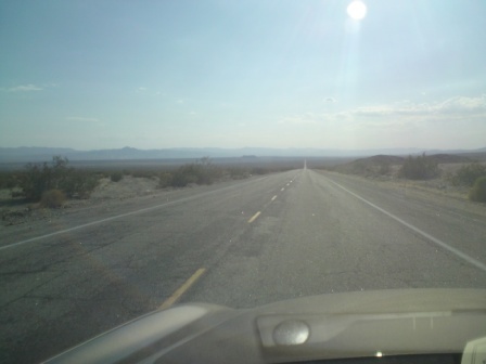
I would normally drive by myself, generally keep to the quieter roads and usually stay over somewhere cheap on the Saturday night. I found driving around on the long empty desert highways whilst listening to podcasts of BBC Radio 4’s Desert Island Discs really therapeutic. Much of the scenery in the south west of the USA is simply spectacular.

It was on one of these early road trips that I first discovered Route 66. I had taken US95 south towards the California border and was heading in the general direction of Palm Springs. Just before I arrived at the (Nevada/California) border town of Needles I saw the brown heritage sign for “Historic Route 66”. I was curious so I turned right on to Route 66 and headed west.

The road had obviously seen better days, but every so often it had the white “Route 66” markers painted in the tarmac. I followed it through a series of hamlets that looked a little derelict and worse for wear: Goffs, Fener, Essex, and Danby. I wondered if I was going down the alphabet and when I passed the next town, “Cadiz” I had a smile on my face.
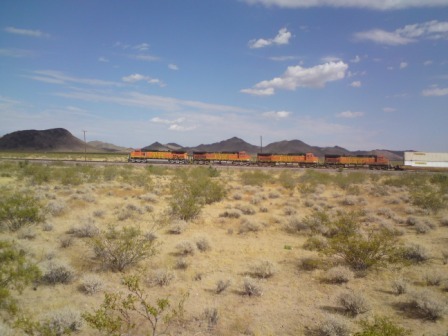
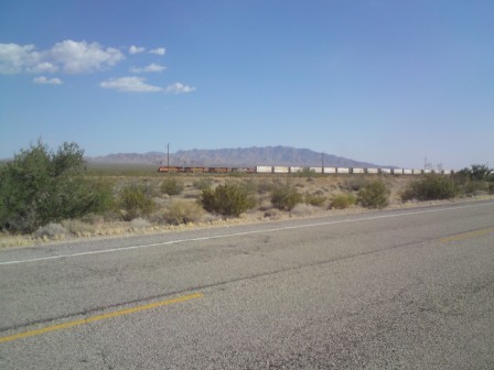
The road was also parallel to the railway line and I could see that freight trains were passing quite frequently in either direction.
A few miles later, at Amboy, there was a service station “Roy’s” open. I pulled in for a closer look.
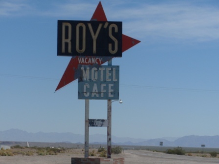
Roy’s had a lot of information displayed about the road. It was obvious that, as well as being a place for people to fill their cars with fuel, it acted as a mini-information centre for Route 66 enthusiasts. In fact there was a list on the wall of some of the Route 66 societies around the world.

I chatted to the guy behind the counter and he told me some of the basics; Route 66 had been opened in 1926, it had run 2500 miles from Chicago to LA and it had been decommissioned in 1985. Parts of the route had been covered over by the interstate freeways that replaced it, but parts of it, like the bit we were standing on, had been bypassed by the freeway and left in place. The guy told me that most of his customers were actually tourists with an interest in the road and, he added, they were growing in number.

He also told me that the reason for the alphabetical town naming was nothing to do with the road itself. It was actually connected with the railway. The Santa Fe railway ran parallel to much of the route and before they constructed the railway they had named prospective stopping points on their maps alphabetically. In other words; the places had received their names even before they existed.

I bought some “dirty food” (ideal for road tripping) from Roy’s and then turned off Route 66 and headed south toward Palm Springs. I vowed to go back and explore more of the road in the future.

A few months later I was back. I headed south from Nevada to meet up with the road again. This time I went a little to the east and ended up in the Arizona town of Kingman. Kingman was obviously proud of its association with Route 66 and had a plethora of signs dotted around the town and even a little museum on the subject. I parked up outside the museum and went in.

The museum was interesting and I learnt a little more about the road by walking around it. Route 66, as I already knew, featured in the Steinbeck novel “Grapes of Wrath” and was the main route people escaping from Oklahoma used to reach a better life in California. To tell this part of the story there were little dioramas of poverty stricken farmers and their families sitting in battered old 1930’s cars. The dioramas were accompanied by lots of photos and memorabilia from the period.
I chatted to the elderly lady who was looking after things and I learnt more. She told me that the road had really been very busy in the 1950s and early 1960s when it had, of course, been immortalised in the famous “Get your kicks…” song. Kingman and the other places it passed through had become boom towns with motels and restaurants setting up all over the place. Many of these establishments had featured outlandish décor and were often marked by giant neon signs and characters.
She told me that the towns had been bypassed in the 1970s by the interstate freeways and many of the businesses had then gone to the wall. Yet, she added, now there was a bit of a revival going on. If a town had a remaining 1950’s restaurant there could be money to be made doing it up, stressing the 66 connection and selling food to the enthusiast crowd. I decided I would become a Route 66 enthusiast myself and I bought a large guide book on the subject.
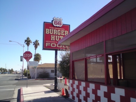
I crossed the road and went straight into the 1950s-style “Mr D’s Route 66 Diner” and ordered a cheeseburger and a coke. I sat eating my food and studying the guidebook. I knew already that it was now impossible to go from Chicago to LA on Route 66 as quite a lot of the route had disappeared, but I soon discovered that it was even more complicated than that.
I read that the route had been diverted several times between 1926 and 1985 and there were several variations in many places. Just between Kingman and the next town west, Needles, there was a 1926 route and a 1940 route. Some of the former was now truncated and most of the later was now built over.

The guide book did suggest that there was a long unbroken section of authentic 66’ stretching directly east from Kingman towards Flagstaff and Williams. I liked the sound of that and that is where I decided to head to next.
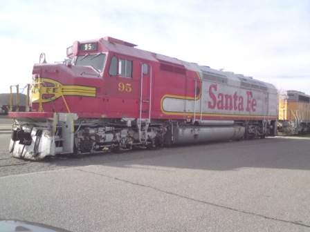
As I left Kingman I noticed a large Santa Fe locomotive on display in the town square. This was evidence that the town had been, and still was, a large railway centre too.

The road east from Kingman was great. There was hardly any traffic but there were plenty of retro-signs and little details to remind me that I was on America’s “mother road”. I had downloaded “the song” and I played it between bouts of Desert Island Discs.
I now persuaded myself I was a 1950’s salesman chugging east in my Oldsmobile going from customer to customer, stopping at diners, staying in motels, and listening to the BBC on an ipod.
After an hour or so I reached Seligman AZ. The town is a Mecca for fans of the road and even hosts conventions on the subject. There was a variety of restaurants catering to the enthusiast and I had a coffee in one that had lots of German licence plates hanging on the walls. The waitress told me people had donated them and she assured me that the road had a lot of fans in continental Europe too.
I carried on a little further until the Interstate appeared and then I watched as it covered up the rest of the 66 route east. I decided that Williams was about as far as I could probably manage in a weekend trip. I would have to leave the Chicago to Williams bit (quite a lot actually) for a longer holiday some other time.
For now I would have to content myself in exploring the western section in all of its different variants. I would not be able to say I had travelled from “Chicago to LA all the way” but I would be able to claim an intimate knowledge of the 1928 rerouting and the 1942 bypassing of some of the more remote Californian towns.
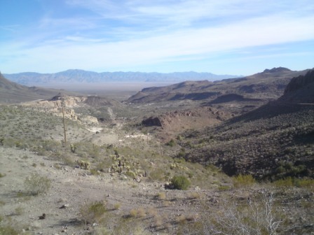
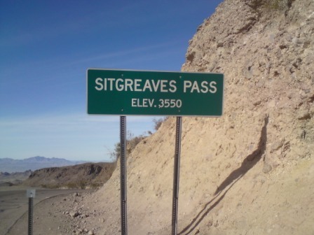
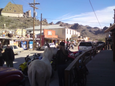
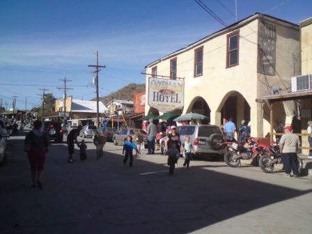
For the next two years I made a series of trips: I filled in the section from Kingman to Needles (1926-40 route) driving up the amazing zig-zag curves up to Sitgreaves Pass and into the quaint little town of Oatman, now a tourist town where real burros wander around the streets freely.


I headed west from Amboy past Baghdad Café (of the film) towards Barstow and yet another Route 66 museum.
I headed south from Barstow towards Victorville, home of the famous airliner graveyard where all the out-of-service Boeing and Airbus planes are kept in the sun.
I discovered the site of the first ever McDonald’s in the back of San Bernadino.


I traced the road slowly through the LA suburbs via Azusa to Pasadena, and finally, I explored all the various routings through downtown LA, rode the state’s first ever freeway (part of route 66 in the 1940’s) and arrived at the “end of route 66” sign at Saint Monica Pier.
For much of the way Route 66 runs parallel to the main railway heading east from Los Angeles. The line is double track and there are frequent freight trains passing along it. The trains are usually carrying containers and most of them are double stacked. The sheer length of the trains is amazing but they actually move relatively slowly. On more than one occasion I found myself chasing them on the parallel road.


I have put the Route 66 guidebook away for now, but I am determined to get it out again soon, get myself to Chicago and complete the whole thing!
