“Pye Hill and Somercotes ..”
Pye Hill and Somercotes (1877-1963) is another example of a station being built to serve two different settlements. In this case it also served two different counties; the hamlet of Pye Hill (along with the station itself) was in Nottinghamshire; the village of Somercotes was just over the border in Derbyshire.

The station was opened by the Great Northern Railway as part of an extension that included Derby in the west and Pinxton in the north. The extension was an attempt to capture traffic from the dominant railway in the area, The Midland, and remove its monopoly.
The line from Kimberly to Pinxton duplicated several of the existing Midland stations which were often within walking distance. Pye Hill itself was just a few hundred yards from Pye Bridge on the Midland Erewash Valley Line.
It was probably a good example of a railway that should never even have opened and when the Beeching Report sought to eliminate examples of duplication, it was a prime candidate. Ironically, many of the original Midland stations, including Pye Bridge, were also lost.
Location
The right-hand X on the map shows the approximate location of the station in relation to the current British railway network. The left-hand X shows the (also closed) Pye Bridge station on the (open) Erewash Valley line. Alfreton, about 3 miles north, on the same line is now the nearest open station. The Pye Bridge to Kirkby freight line is also shown in black.

The red dot on the map below shows the approximate location of the station in relation to the local area. The purple dot shows the approximate location of Pye Bridge.

Services: Past, Present & Future?
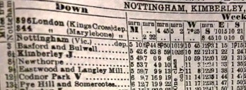
In 1962 there were just 5 trains a day linking the line’s terminus at Pinxton South (3 minutes away) with Nottingham Victoria (40 minutes). There were no trains in the evenings or on Sundays.
A bus into Nottingham today takes around 70 minutes.
Whilst there is no hope for Pye Hill, there is a chance that Pye Bridge could reopen and possibly one day offer services to Nottingham and even to the new proposed HS2 station (yellow triangle on the map above) at Toton.
Station Site
The station site had been completely obliterated. The cutting that it used to occupy had been filled in and was now covered with significant vegetation. The only signs that a railway once came through here were the parapets of the over bridge on the B600 between Pye Bridge and Selston Green.
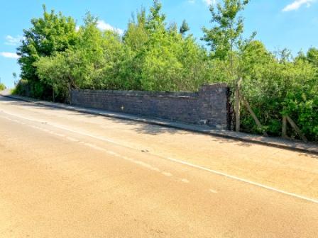
Peering over the parapet on the south side of the road would once have given a clear view of the station below. Now it was impossible to even look over; there were just dense bushes and nothing to see through them at all.
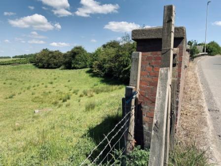
Peering over the parapet on the north side would have given a view of the railway emerging under the bridge below as it curved away towards the terminus of the GNR line at South Pinxton. Today the ground had been filled up to the crown of the bridge and looking at the field it was almost impossible to imagine anything was ever there.
Surrounding Area
Without much time to spare, but wanting to explore a little more, we decided to make a quick anti-clockwise loop passing through several villages before returning to the same spot.
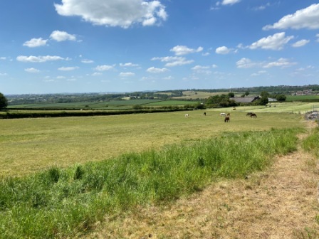
First, we headed east; climbing halfway up the hill in front of us, before turning back to survey the scene below.

Looking back towards the parapets we could see the Erewash Valley Line beyond and just as we were looking a train passed heading north towards Alfreton. On the other side of the railway, well hidden, was the River Erewash itself. It forms the boundary here between the county of Nottinghamshire where we stood and the county of Derbyshire that was laid out in front of us.
The road curved away to the left from the parapet and then, after passing under the Erewash Valley Line where Pye Bridge station used to be, crossed the river, and headed through the village of Pye Bridge.
We turned around again and continued up the hill to Jubilee: a hamlet on the top. Like most of the villages around this part of Nottinghamshire it has a strong industrial heritage. Many of the settlements used to be mining communities but there were also brick works and, as at Pye Bridge, ironworks too.

We headed through Jubilee and after turning northwest through Selston Green we paused for a minute again to look back at the view. The landscape was deceptive; at first sight it looked extremely rural but on further inspection it revealed its industrial past. Nottinghamshire Tourism are trying to market the area as the “hidden valleys”, and they are using the memory of novelist DH Lawrence (who was born two stations south of Pye Hill at Eastwood) to help gather interest. “DH Lawrence Country”: say the signs.
At Pinxton we crossed back into Derbyshire. The level crossing over the Pye Bridge-Kirkby freight-only line is the county border here. The line itself is very historic and was once part of the Pinxton to Mansfield Railway which, opening in 1819 and using horse drawn wagons to transport coal, is one of the oldest railways in the world.
There is talk of opening this section to passenger trains again so that the people of Mansfield and Kirkby can access the new HS2 station to be built west of Nottingham at Toton.

Coal was also transported on a branch of the Cromford Canal (part of which we had walked along back at Ambergate) that ended at Pinxton. The bridge over the canal, long since removed, was depicted in the 1960 film of Lawrence’s novel “Sons and Lovers” which was set in and around the Nottinghamshire coalfield.
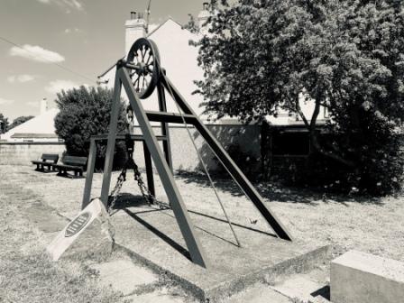
Like all the county’s pits, Pinxton is now closed, but its heritage is celebrated in several little memorials dotted around the village. One of them, in the form of a headstock, celebrates inventor John King whose detaching hook, a safety device which detached the cage from the rope, was first successfully trialled at Pinxton in 1873.
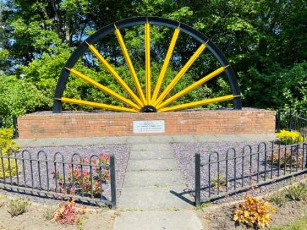
From Pinxton we continued around to Somercotes. It seemed like a bustling little place with plenty of industrial estates, new housing, and busy shops. A large pit wheel, painted bright yellow, was evidence that this village too once relied on coal for its existence. I spoke to an elderly man sitting close to the memorial. He had never heard of Somercotes ever having a railway station. You could not blame him; considering that you would have had to walk a few miles just to get to Pye Bridge station, then walk past that and only then reach the railhead that got the “& Somercotes” label.
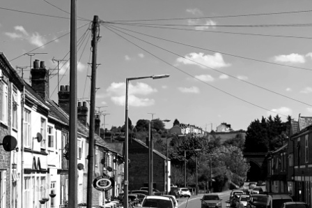
We arrived in the little village of Pye Bridge. As we passed along the narrow street with its rows of cars, it was not hard to imagine workers pouring out of the iron works heading home after a shift and possibly even popping in the Dog & Doublet for a pint.

Having almost completed the circle, we crossed the River Erewash and went under the railway bridge near the site of Pye Bridge Station. Now back in Nottinghamshire again, we could see Jubilee again perched on the hill straight ahead.
Standing here in 1962 we would have had the choice of trains from Pye Bridge just behind us or Pye Hill (& Somercotes) just in front of us. Either one would have taken us into the centre of Nottingham in less than 40 minutes or so.
Slow train to 31) Windmill End
