“The Pines Trail”
My aim was to create an enjoyable route through Somerset and Dorset that would stay as close to the old railway as possible but try not to get too obsessed with it. I included as many of the old station sites as possible but also diverted occasionally if things looked a little more interesting away from the line.
I chose the Bristol suburb of Yate as my starting point. The line (used by the Pines Express) from Manchester via Birmingham is intact north of here and it is still used by trains today. Today’s passenger trains “turn off” at Yate South Junction and head south west towards Bristol.
“The Pines Express” used to head straight down towards Bath and eventually on to Bournemouth on lines that were lost in the late 60s.
My “Pines Trail” would start near that junction and then “fill in” the missing part of the route over the next 90 miles south. It would pass through the eastern suburbs of Bristol, skirt the centre of Bath, climb in the Mendip hills, head across into Dorset, along the banks of the River Stour and finally meet the coast at Poole to head into Bournemouth itself.
I thought about ending it at the site of the old Bournemouth West station or even at a specific pine tree in the Upper Gardens but, influenced by Route 66 and Santa Monica, I eventually chose Bournemouth Pier as a suitable terminus instead.
MAPS & INSTRUCTIONS
I used the instructions listed below to navigate on my trip.
I also used maps I had created using Openstreetmap.org to supplement the instructions.
The maps are included here only to illustrate the instructions and should not be depended on for navigation.
I have adapted the original maps by showing them in black & white. I have added colours to illustrate my route and the path of the old railway.
My route is generally shown in Green.
Where the route follows the old track bed on footpaths or cycle tracks, it is shown in Orange.
Points of interest referred to in the instructions are shown by letters.
The approximate positions of stations that the Pines Express would have passed through or stopped at (after Yate) are shown by numbers.
The approximate position of the rest of the old track bed is shown in Red.
Note that although there are other sections of the track bed that can be walked on, most of it is now private property, a lot of it is overgrown and some of it has been built over. No right of way should ever be assumed.
Also note that although a limited number of old railway buildings are now in use as private dwellings, it is very important to respect the privacy of the owners / residents.
All distances quoted are very rough estimates only.
YATE TO BATH (15.75 miles)
Leave Yate Station (A) on the A432 (Badminton Road/Station Road), turn off and walk south along the western edge of Yate Common, keeping the railway to the right.
At the southern end of Yate Common turn right under the railway bridge and emerge onto Nibley Lane.

The southbound Pines Express would have passed through the station at Yate just before heading over Yate South Junction (y). At that junction it would have taken the main Midland route that led to either Bristol or Bath.
A little further on (i) it would have gone under the Great Western Railway’s South Wales Main Line. The chord that branched off from Yate South Junction to the GWR line is still in use and today it is part of the main route from Birmingham to Bristol.
There is an over bridge (B) here and it is worth a peek over it. Looking north, Yate South Junction can almost be seen. The old Midland line here still exists but (now single track) ends just a short distance further south at an oil depot.
Continue along Nibley Lane as it becomes Westerleigh Road and passes under the main London-South Wales (GWR) railway line and heads into Westerleigh village.
After passing a church (C) in the village, cut across the fields on a footpath.
As the footpath emerges at Westerleigh Road (D) turn right and follow the road west.
The ex-MR line can be seen again from another over bridge. Looking south from here the shortened single track branch is visible just before it ends at the oil depot at Westerleigh Railhead. South of here (after the M4 bridge) the track has been removed. The track bed becomes a cycle path just south of the M4 (G).
At Kidney Hill (E) turn onto a footpath and follow it south until it intersects with the “Dramway” path just before the M4 motorway bridge (F).
Follow the Dramway (the route of an old tramway) path under the motorway until it reaches the track bed of the old Midland Line (G).
An brief optional trip back along the path from (G) northwards towards the railhead under the M4 can be made.
This is the “Bristol to Bath Railway Path”. Follow it as far as Dramway Roundabout (H).
Follow the “Dramway” path on the east side of the A4174, past Mangotsfield until it intersects with the main “Bristol to Bath Railway Path” after the Siston Hill Roundabout (I).
The Midland Railway had a triangular junction at Mangotsfield.
The Pines Express would have followed the north-south chord that avoided Mangotsfield Station (X). Outside of the busy summer period, it was usually the only passenger train to do so.
Most services coming from the north (via Yate) branched off on the north-west chord here. Most trains coming in the opposite direction from Bath used the south-west chord.
The two chords met at Mangotsfield Station (X) and formed the line that led into Bristol. Shown in purple on the map above, both chords and the entire Bristol line are now cycle trails.
After Siston Hill (I), the “Bristol to Bath Railway Path” can now be easily followed into the centre of Bath.

The Pines Express would have continued on its way south passing through the Midland stations at Warmley (1), Oldland Common (2), Bitton, (3) and Kelston (4).
Between Oldland Common (2) and Bitton (3) the Avon Valley Railway has restored track and is doing an excellent job of recreating the atmosphere of the old Midland Railway.
Steam trains run on certain days of the year and there is even a “Pines Express” with dining car! The trains extend southwards to a new station: Avon Riverside (J) between Bitton and Kelston.
On the outskirts of Bath the “Railway Path” leaves the old track bed (K).
After passing through Weston Station (5) the Pines Express would have crossed the River Avon twice before it arrived at Bath Green Park (6). The station at Green Park was a terminus and all “through” trains reversed there.
Follow Brass Mill Lane down to the River Avon and then follow the river to Windsor Bridge (M).
A short diversion (shown in lime above) to the site of Weston Station (5) is possible by following Station Road north from the River (L) and then Newbridge Road east back to Windsor Bridge (M).
Continue to follow the path along the river to the old station building at Green Park (6). Today it is a car park for a supermarket and a food market on Saturdays. The building is well preserved and well worth a visit.
BATH TO MIDSOMER NORTON (13 miles)
From Green Park Station (6), return back along the river to Windsor Bridge (M) and then cross it.
The next part of the route follows the track bed of the Somerset & Dorset line. It begins at the start of the “Two Tunnels Greenway” just south of the river (N) near Windsor Bridge.
After a wait of around 5 minutes, the train, possibly now with a pilot engine assisting the main locomotive, would have headed back out of Green Park and then turned south at Bath Junction onto the Somerset and Dorset line (N).
The heavy Pines Express would have faced a difficult two-mile climb on the single track section as it left Bath Junction. The climb began immediately and continued through Devonshire Tunnel (B) and all the way up to the mouth of Coombe Bank Tunnel (C).
There would then have been some respite from steep gradients as the train headed around to Midford (7) and, on double track, onwards to Wellow (8) Shoscombe & Single Hill Halt (9) and Radstock (10).
The line passed over the main GWR London to Bristol line (still in use) just after Bath Junction (ii) and then after Midford (iii) it passed over the GWR Camerton Branch (abandoned and shown in brown).
The track passes through Devonshire (B) and Coombe Bank (C) Tunnels before crossing Tucking Mill Viaduct and looping around to Midford station (7). The platforms still exist.
Just before Wellow (8) the cycle path on the track bed comes to an end.
Divert onto Ford Road (D) and follow it (Signposted Cycle Route 24) as it becomes High Street through the village.
Turn left onto Railway Street at the Fox & Badger pub.
A diversion towards the site of Wellow Station (8) is possible by continuing along High Street and turning into Station Road. It should be noted, however, that the building is private property.
Follow Railway Street to where it ends at the old S&D formation. The old Wellow Signal Box is visible here.
Take the footpath that continues from Railway Street on the other side of the formation.
Follow the footpath over Wellow Brook until it emerges onto Mill Hill.
Follow Mill Hill and then bear right to Hassage Hill (E).
Take a footpath across Long Barrow towards Stoney Littleton Farm.
Follow the footpath until it intersects with Dairy Hill. Turn right and then follow Faulkland Lane to Stony Littleton.
Turn left (F) and follow the footpath along the track bed once more.
There is a short diversion off the track near the old Shoscombe and Single Hill Halt (9).
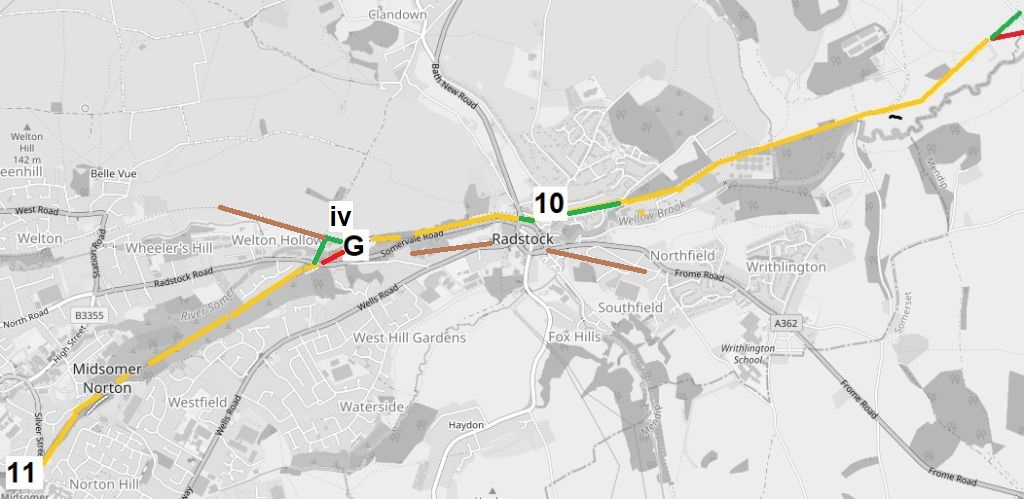
The train would have begun to climb again after Radstock North (10) and would have continued climbing as it passed through Midsomer Norton South (11).
The GWR had their own station at Radstock. “Radstock West” was on their line from Frome and was actually adjacent to the S&D station. The GWR line (shown in brown above) passed under the S&D (iv) west of Radstock and continued through a separate Midsomer Norton station on its way to Bristol.
The S&D station at Midsomer Norton, along with a short section of track, has been restored by the Somerset & Dorset Railway Heritage Trust. There is a buffet and a shop. Trains sometimes run up the line towards Chilcompton Tunnel too. The whole operation is certainly worth a look.
Continue on the track bed again for the next few miles towards Radstock.
Just before Radstock the trail ends. Follow Waterloo Road to the Colliery Wheel Memorial that now stands on/near the site of the old stations (10).
Cross Bath New Road and follow “North Radstock Greenway” to the point where it forks with the “Somerset & Dorset Path”
Follow the “Somerset & Dorset Path” (running parallel to but higher up than the “North Radstock Greenway”) to the Five Arches Bridge (G).
Cross the bridge. This is the old bridge that took the Somerset & Dorset across the GWR line; the trackbed of the latter is now the “North Radstock Greenway”.
After the bridge, the S&D formation is blocked for a short distance. Turn right and head towards the “North Radstock Greenway”.
Follow the “North Radstock Greenway” for a short while and then take a footpath on the left.
Follow the footpath across the River Somer and over Radstock Road back to the S&D track bed.
Turn back onto the S&D track bed, here called “Five Arches Greenway”, and follow it to Silver Street and Midsomer Norton station (11).
MIDSOMER NORTON to SHEPTON MALLET (10.75 Miles)
Cross Silver Street in front of Midsomer Norton Station (11) and then go across to the footpath on the other side. This is Silver Street Nature Reserve.
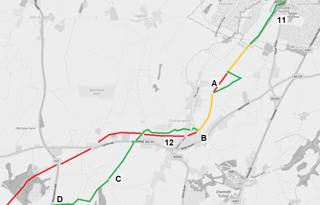
After Midsomer Norton, the train would have gone through the short Chilcompton Tunnel (A), and then, still climbing at 1 in 50/60, would have passed stations at Chilcompton (12) and Binegar (13).
Go left at both of the next two forks in the path. Emerge from the nature reserve on a footpath heading alongside the preserved line.
Continue alongside the reinstated track until it ends. Beyond here the northern portals of Chilcompton Tunnels are sealed up and the approach cutting has been filled in.
Turn left off the track bed. Follow the footpath to Tunnel Lane. Turn right onto the lane and follow it down until it crosses the old formation.
Take the footpath on the left and go back onto the track bed. The southern portals of the Chilcompton Tunnels (A), now being used as a rifle range, is visible just behind on the left.
Follow the footpath back on the old track bed as it curves around towards Chilcompton.
Turn right onto Fry’s Well at (B) and then left into Baker’s Lane.
Soon afterwards there is a footpath on the right hand side, take it and follow it down to the river.
After crossing the river, follow the footpath as it turns into Valley Walk. Chilcompton station was here on the right (12).
Just before the footpath emerges onto Parsonage Lane take another footpath on the left and follow it (crossing the S&D formation) towards Broadway.
Turn right into Broadway and after a short distance (opposite the junction with Parsonage Lane) take another footpath.
Follow the footpath across Coal Pit Lane (C) towards Cockhill Farm.
Cross Marchant’s Hill (A37) (D) and cut across to Portway Lane on a footpath.
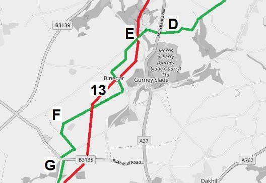
The summit of the line was reached after Binegar. The train would have then encountered equally steep downward gradients as it passed through Masbury (14), Windsor Hill Tunnel (J) and descended towards a possible stop at Shepton Mallet.
On the approach to the town it would have crossed the impressive (and still standing) Charlton Viaduct (L) before arriving at “Charlton Road” station (15).
Turn left on Portway Lane, the S&D formation crossed here at Portway Bridge (E) and the remainder of the bridge can be seen.
After passing Turner’s Court Farm on the right, take a footpath off to the left.
Turn right onto another footpath and then right again towards Binegar to emerge at a junction of Tellis Lane and Station Road.
Follow Station Road, past the site of Binegar Station (13). The station is no more, but some houses connected with the railway remain.
After passing the “Horse & Jockey Pub” on the right, turn right on a series of footpaths heading towards Whitnell House Farm.
After passing Whitnell Farm (F), keep left and emerge onto the road.
Take a right turn and head in the direction of Broomclose Corner (G).
From Broomclose Corner follow the road south to Masbury. Masbury Station (14) used to be here. It is now a private dwelling.
Turn left onto Old Frome Road and follow it as far as Thrupemarsh Farm.

Turn right following a footpath (take care as the route has been altered by the landowner and a permissive path replaces the one shown on maps) that passes in front of Burnt House Farm (H) and heads towards Mill House Farm.
The footpath ends at Windsor Hill Lane. Turn right into the lane and soon after turn right into Ham Lane and follow it until just before it meets the old S&D formation (J).
The southern portals of Windsor Hill Tunnels are just north of here. It used to be possible to walk through them but they have been gated up in recent years.
Before crossing the old railway, turn immediately right and head down a footpath that runs along the left side of the line.
At a footpath T-junction take the right fork and head back over the S&D formation once more to meet Forum Lane.
Retrace steps on Forum Lane back to the old track bed and then follow the footpath along it for another short section.
Just before Bath Road viaduct (blocked off by fencing) the footpath heads off the track bed sharply to the right, follow it until it emerges onto a little road called Gold Hill (K).
Cross over the B3136 and follow the footpath directly opposite, now the “East Mendip Way”, as it heads back towards the old line.
Follow the “East Mendip Way” as it skirts the north of Shepton Mallet with the impressive old railway viaduct at Charlton on the right.
Where the “East Mendip Way” branches off to the right (L) carry straight on until the footpath emerges into Brewery Lane.
Follow Brewery Lane until it meets the main Charlton Road (A361).
Shepton Mallet “Charlton Road” Station (15) was once across the road from here on a site that is now occupied by an Industrial Estate.
SHEPTON MALLET TO WINCANTON (15 Miles)
Head down Charlton Road until it meets a junction with Frog Lane.

As the Pines Express left Shepton Mallet (15) it would have encountered the GWR yet again: their Whitham-to-Yatton line (V) crossed over the S&DJR here and they also had their own station (High Street) in the town. A little further east (at Cranmore) part of this line has now been preserved as the “East Somerset Railway”.
The train would then have crossed another impressive, but sadly now lost, viaduct at Priestleigh before passing through Evercreech New (16).
Soon after, the branch (original main line) from Burnham converged on the right just before the station at Evercreech Junction (17). This was quite a busy centre for the railway: the “Crewe” of the S&DJR system.
If a train had used a pilot locomotive to assist over the hills from Bath, it was often removed here. A line of engines waiting to pilot northbound trains could often be seen here on busy summer Saturdays.
Turn right and head down Frog Lane and follow it as it turns into a footpath and climbs Whitstone Hill.
Turn left (A) and follow the footpath in the direction of White Slight Farm.
Turn right (B) and follow another footpath heading down to Lower Farncombe Farm.
Turn right (C) before the farm and head towards Priestleigh on a footpath that becomes Priestleigh Lane.
The lane crosses the old S&D formation just before it reaches the A371 (D).
Turn left onto the A371 and head south for a short distance before turning left on to the B3081 heading into the little village of Evercreech.
Just before the town, turn right along a track / footpath towards Horsehill Farm.
Continue on the footpath on the edge of Leighton Industrial Estate until it emerges onto Leighton Lane (E).
Turn Left along Leighton Lane and head into the Village. New Evercreech Station (16) used to be to the south of here.
At the end of Leighton Lane turn right into High Street (B3081).
Turn right into Oxford Street just before St Peter’s Church and follow Oxford Street round to its junction with Rodmore Road.
Take the footpath heading for Southwood Common (F).
Take the left fork footpath after crossing a stream on a footbridge and follow it as it goes south of Southwood Farm and back on to the A371.

Turn left and go south on the A371 for a short distance.
This is Evercreech Junction (17). The station site is now an industrial estate.
Pass the Natterjack pub (the old Station Hotel) and then turn left (G) on a footpath heading towards Lamyatt.
Walk through Lamyatt on Portway Hill and then turn right onto a footpath heading towards Creech Hill.
Turn right (H) onto another footpath and head towards Wyke Farm (J).

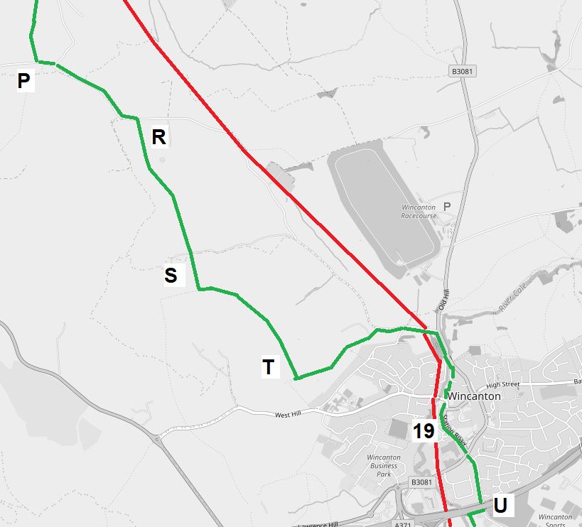
Having left Evercreech Junction, the train would have then passed through Cole for Bruton (18) and Wincanton (19) on its way down to Templecombe (20).
Just before Cole, it would have had had its final encounter with the GWR (vi) as it crossed the (still in use today) Paddington-to-Taunton line.
After Wyke Farm, cut across the field on a footpath and head towards Pomeroy Farm.
Follow Wyke Lane down to the point where it passes under the Paddington-to-Taunton Main Line (K).
At the point where Wyke Lane meets Sunny Hill, go straight across (slightly to the left) onto a footpath which eventually emerges onto Mill Lane (L).
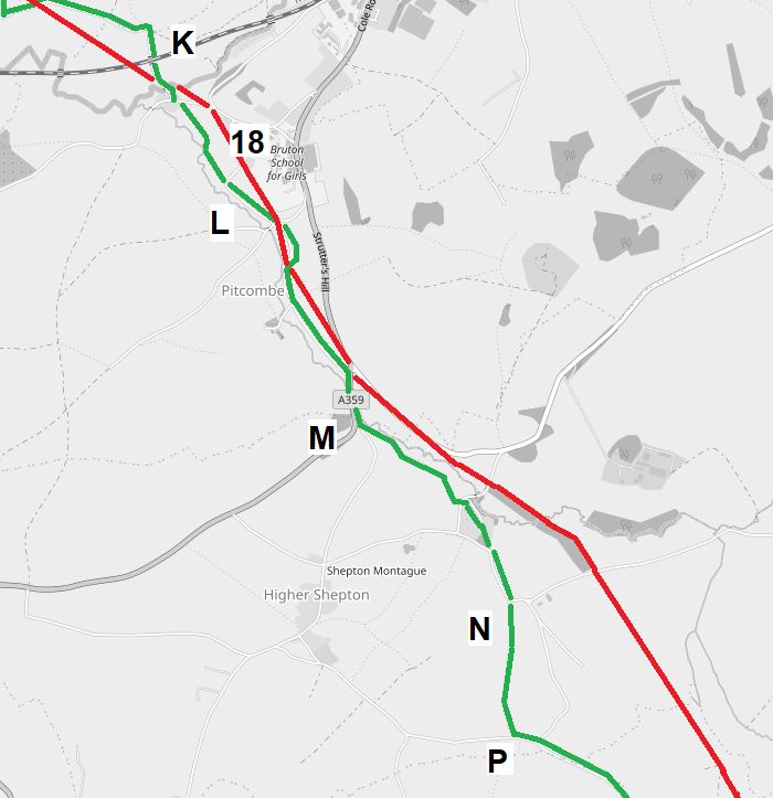
Cole for Bruton Station (18) was located just to the east of here. It is now a private dwelling.
Follow Mill Lane south as it goes east under the old S&D formation and then back west again.
Where Mill Lane ends at a T-junction with the A359, turn right and soon after take a footpath on the left (M).
Follow the footpath until it emerges onto a road. Turn right and follow the road to a T-junction and then turn left.
After passing Lower Farm take a footpath (N) heading across the fields to Southdown Farm (P).
From Southdown Farm follow the road (Verrington Lane) until it passes the entrance to Higher Cuttlesham Farm (R).
Turn right onto a footpath that begins by following the track into the Cuttlesham Farm and then continues past Westleaze Farm.
At a T-junction of footpaths (S), go left and head past Suddon Farm before heading left once more at another T-junction (T).
Follow the footpath until it emerges onto Verrington Lane.
Verrington Lane ends, after crossing the S&D formation, at a T-junction with Old Hill.
Turn right onto Old Hill and follow the road towards the centre of Wincanton.
Take the second right, Waterside Road, and follow the footpath at the end of it until it links to Mill St.
Keep straight, passing the Millers Pub on the right, and eventually emerge onto Station Road.
“Pines Close” and the site of Wincanton Station (19) is on the right.
Cross over South Street and continue on the other side as Station Road turns into Moor Lane.
Follow Moor Lane as it crosses under the A303 dual carriageway (U).
WINCANTON to STURMINSTER NEWTON (15.5 miles)
Immediately after crossing under the A303 (U), head off to the right on a footpath.
It is signposted as “Monarch’s Way”.

Head south to Maltkin Farm and then turn right heading west still on “Monarchs Way”.
After the footpath crosses the old S &D formation, turn off “Monarchs Way” to the left (A) and head on another footpath towards Marsh Lane.
Cross Marsh Lane and then continue along the footpath until it reaches Duck Lane (B).
Turn right and head along Duck Lane towards Horsington.
Before reaching the centre of the village, turn left and head along a footpath (C) towards the A357 on Tower Hill.
Join the A357 and walk into Templecombe on it.
The site of the “old” lower station (20) is now an industrial estate.
Leave Templecombe staying on the A357 until a junction at the end of the High Street (D)
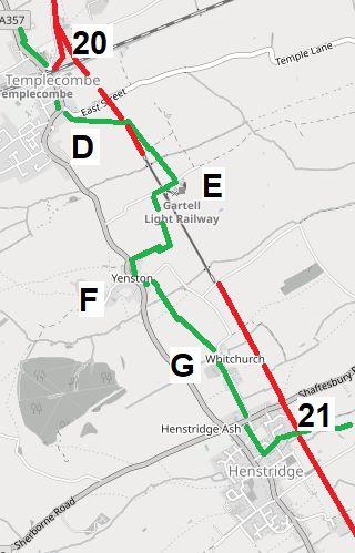
At Templecombe the double track section from Midford ended and the line split. A chord went south west and connected to the LSWR “upper” station. That station still exists today and is a stop on the Waterloo to Exeter line.
The S&D main line went through a “lower” station (20) and then continued south, as single track, towards Bournemouth.
Several through trains on the S&D including, at one time, the Pines Express actually used the “upper” station at Templecombe. This made connections with the LSWR line easier, but the movement was complex and required a reversal out of the station and then another reversal to continue the journey south.
Turn left along East Street, then take a footpath towards Common Lane Farm (E).
Turn right here and head past the Gartell Hill railway.
This privately-owned narrow gauge railway operates on a limited basis along some of the old track bed of the Somerset and Dorset. It aims to recreate, in miniature, some of the atmosphere of the old line.
Turn immediately south again on another footpath heading south. Keep the little railway to the left.
Eventually the footpath turns to the right, follow it towards Yenston (F).
Use the A357 very briefly to go a few yards south.
Turn left onto Whitchurch Lane, then turn right immediately onto a footpath.
Follow the footpath (G) across to Court Farm and Whitchurch Lane.
Follow Whitchurch Lane until it ends at a T-junction with the A30.
Turn left onto the A30 and then immediately right into Old Station Gardens, link south to Station Road and then turn left.

After Templecombe the route got flatter and, although on single track, the pace quickened. The train would have passed Henstridge (21) Stalbridge (22) and Sturminster Newton (23) in quick succession.
Henstridge Station (21) was at the end of Station Road. The stationmaster’s cottage still stands.
Continue along Station Road as it becomes Plott Lane.
Connect on a footpath from Plott Lane to Marsh Lane and then turn right onto another footpath heading to Rhodes House Farm (H) on Landshire Lane.
Landshire Lane is the border between Somerset and Dorset.
Head on another footpath from Landshire Lane to Stalbridge. Enter Stalbridge on Station Road.
Turn left on Station Road and follow it until the “Sidings” industrial park. Stalbridge Station (22) was located here and the site is now occupied by the park.
Turn right onto a “Trailway” along the track bed and follow it by the side of the industrial estate.
Turn left and head towards Gomershay Farm (I). From Gomershay Farm head south east towards a footbridge across the river.
Cross the bridge and head towards Common Lane, turn right onto Common Lane.
After a short distance, turn left and head across a field towards Phillips Hill.
Go across Phillips Hill and follow Bat Alley as it turns into a footpath.
The footpath soon intersects with the “Stour Valley Way” (J).
Follow “Stour Valley Way” south as it passes Antell’s Farm, Cutt Mill, and then the banks of the River Stour into Sturminster Newton.
The old S&D railway bridge, still partially standing, can be seen from the river bank on the way into Sturminster.
After passing under the old railway, turn right (K) onto a footpath and head east into the town.
The footpath turns into The Row, follow it across Bath Road as it becomes Station Road
The old Sturminster Newton Station was here (23).
STURMINSTER NEWTON to SPETISBURY (12.75 miles)
From the station site at Sturminster Newton, the North Dorset Trail (Cycle Way 250) begins and the old S&D track bed can now be followed intact for several miles through Blandford Forum all the way to Spetisbury Station.
There are a couple of short well-signposted diversions off the track bed north of Shillingstone and near Stourpaine, but otherwise everything is straight forward.

The Pines would have continued on through Shillingstone Station (24) Stourpaine & Durwest Halt (25) before making another stop at Blandford Forum (26).
Shillingstone is now the site of another ambitious preservation project: The North Dorset Railway Trust have already restored the station and have a long term goal to reopen the line up towards Sturminster Newton.
Enter Blandford on the cycle path and continue on the old track bed until it ends at Station Court.
Blandford Forum Station (26) was once here but now it is part of a modern housing estate.
Turn right from Station Court onto Damory Court Street and follow it down until its junction with Wimborne Road (A).

After Blandford the train would have been back on double track again down to Corfe Mullen. Stations at Charlton Marshall (27) Spetisbury (28) and Bailey Gate (29) would have been passed on the way through.
Go straight across Wimborne Road (A) into Langton Road.
Enter the M&S car park on the right and then pick up a footpath that begins in the car park.
Follow the footpath across the river and alongside a business park towards the roundabout where the A354 and A350 meet (B).
Follow the A350 (Bournemouth Road) south for a short distance and then turn right on a track heading towards Home Farm (C).
The route now resumes on the old track bed.
A few miles further south at the end of the cycle track (D) turn left onto Louise Lane.
SPETISBURY to BROADSTONE (11 miles)
Cross the A31, then cross the River Stour at Crawford Bridge.

Turn right almost immediately onto the “Stour Valley Way” and follow it along the east bank of the river as it curves around through Shapwick (E) and on to White Mill.
Cross White Mill Bridge (F) and follow the road into Sturminster Marshall.
When the road forks, take the left hand fork and follow the High Street towards the village.
Turn onto “Wareham Forest Way” (G) follow the path across fields until it reaches the S&D formation (H) and then the A31 (J).
A short diversion is possible (shown in lime) down to the village and the site of Bailey Gate Station (29). There is now an industrial estate where the station once stood.

The original Somerset & Dorset Line actually went through Wimborne Minster. Trains would have to reverse there in order to reach Poole. A “cut off” line was built later to bypass Wimborne and Corfe Mullen Halt (30) was located on this new line.
The original line, which subsequently became a branch, continued roughly in the same direction as the current A31 towards Wimborne Minster. It is shown in purple.
The cut off continued around to Broadstone Junction (31) where it met the line coming from Wimborne (shown in purple and now a cycle track).
This was the official end of the Somerset and Dorset Joint Railway; for the remainder of its journey, the Pines Express would have continued on LSWR track.
After walking for a short distance along the A31 (take extra care!), turn right onto a permissive footpath (K) that follows the S&D formation. Look out for the old crossing keeper’s cottage at Knoll Lane.
The footpath ends at Brog Street (L). Follow Brog Street as it becomes Candy’s Lane.
After a while, turn right onto another footpath that crosses the old S&D formation and eventually intersects with Wayground Road.
Follow Wayground Road until it meets Wimborne Road at a T-junction.
Go across Wimborne Road, slightly to the left, and take the road directly opposite: Pine Road.
Follow Pine Road until it curves to the left and then continue onto the footpath at the end until it intersects with the old S&D formation. The site of Corfe Mullen Halt (30), now built over, is on the left.
Follow the footpath east of the track bed for a short distance. Eventually it leads back onto the S&D formation at Ashington Cutting (M) and then follow it until it reaches Merley Park Road.
Climb up from the cutting to Merley Park Road and then head on a Bridleway that cuts across Rushcombe Bottom.
Turn left along Higher Blandford Road.
After Passing Corfe Hills School on the right, turn left into Higher Blandford Road (loop).
Before the end of Higher Blandford Road (loop) (X), take a footpath across towards the Castleman Trailway / Wentworth Drive (Y) .
Head south towards Broadstone Roundabout.
On the way towards the roundabout is the site of Broadstone Junction Station (31). Part of it is now the Broadstone Leisure Centre.
The old station hotel building is still standing and is now a bar: “The Goods Yard”.
Wentworth Drive becomes Station Approach as it nears Broadstone roundabout (N); the cycle path passes underneath the roundabout in a subway.
BROADSTONE to BOURNEMOUTH (11 miles)
From the roundabout (N), follow Cycle Route 25 on the old railway formation (which is elevated here) alongside Broadstone Way until Beechbank Avenue (A).
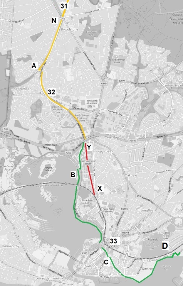
Now on the LSWR, the train would have continued past Broadstone Junction. Slightly further south (A) the railway split; one chord (the original line) went west and the other chord (followed by the Pines Express) went east. Just after this point was Creekmoor Halt (32).
After another mile and a half, the train would have joined the main Weymouth to Waterloo line (still open today) before making its penultimate stop at Poole Station (33).
This point (X) marks the end of the 90+ mile “missing section” of track that began at the railhead near the M4 just south of Yate.
At Beechbank Avenue cut across to follow Cycle Route 25 on Broadstone Way past the site of Creekmoor Halt (32).
The old track bed is hidden under Broadstone Way for the rest of the route until it disappears under Fleet Industrial Estate (Y to X).
Follow Broadstone Way until it becomes the A349 and emerges at the Holes Bay Roundabout (B).
Pick up the “Poole Harbour Trail” and follow it around the waterfront to Poole Railway Station (33). The path soon passes over the Weymouth to Poole / Waterloo line.
From Poole Station cut through the Old Town (C) – signposted Cycle Route 25 – to reach the harbour front.
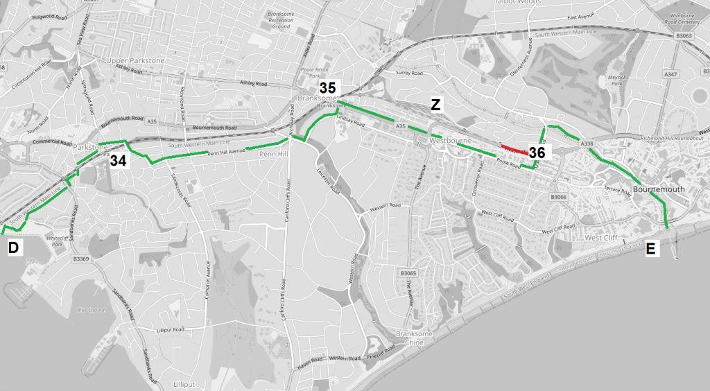
The Pines Express would have continued its journey by climbing steeply and passing through Parkstone (34) and Branksome (35). This line and both stations are still open today.
After Branksome it would have turned south off the main line (which headed towards Bournemouth Central) and then passed over track that is still in use today as access to a train depot (Z).
More than seven hours after leaving Manchester, the train would have finally ended its journey at the buffer stops at the old Bournemouth West (36) terminus.
The station closed in 1965. The last part of the track (shown in red) from the depot has been removed, the station has been demolished and the site is now occupied by a car park and the “Wessex Way” overpass.
Across the street, however, the historic station hotel building still stands and is now an apartment block. It is named, rather appropriately, Midland Heights!
Head through Baiter Park and then branch off (D) to the left and climb up towards Whitecliff Road.
Turn right on reaching Whitecliff Road.
For rest of the journey, the route follows a string of roads and avenues through Poole and into Bournemouth.
Whitecliff Road, Sherwood Ave, Sandbanks Road, Salterns Road, Approach Road, Station Road, Parkstone Station (34)
Osborne Road, Kingsbridge Road, Woodside Road, Penn Hill Avenue, Leicester Road, Lindsay Road, St Aldheims Road, Branksome Station (35)
From Branksome, follow Poole Road via County Gates Gyratory to the junction with Queens Road.
Turn left into Queens Road and walk past the old site of Bournemouth West Station (36).
Continue on Queens Road until it intersects with Upper Gardens. Follow the paths down to the sea, first through Upper Gardens and then Lower Gardens.
The journey ends at the entrance to Bournemouth Pier (E).
Estimated total distance from Yate – 105 Miles
Return to “On the trail of the Pines Express”
