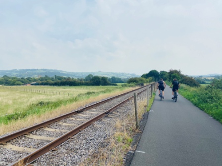
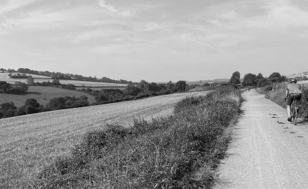
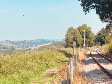
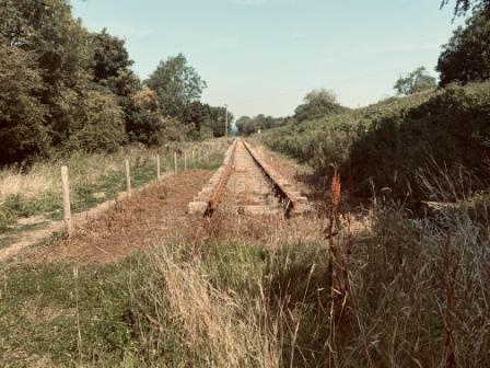
Walking on the track bed of the Somerset & Dorset line
A Path of your own
Alfred Wainwright, the celebrated inventor of the Coast-to-Coast path, once suggested that, rather than just following routes created by others, people should try to come up with their own individual walking trails. He claimed that there was simply no end to the amount of possibilities that could be created using a map and a pen.
I have always been fascinated by how long-distance routes like the C2C, Pennine Way or the South Downs Way are actually put together from a seemingly random collection of pre-existing individual footpaths. Sometimes I have even thought that it would be interesting to have a go at sticking one together myself.
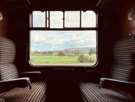
Meanwhile, a couple of years ago I ran the Two Tunnels’ Marathon in and around the city of Bath. The race included sections on the old track bed of the long-closed Somerset and Dorset line. I became interested in that railway’s history and, in particular, I became intrigued by its most famous train: the “Pines Express” which used to link Manchester with Bournemouth.
I can’t really explain why, but something about that journey down from the industrial north to the south coast seemed to fascinate me. Maybe I imagined myself on the train in the 1950s, looking out of the window as Somerset and Dorset passed by and that long-awaited seaside holiday got closer and closer.
Read more about the “Pines Express”
A long green line
With a little more time on my hands than usual, partly due to COVID-19 lockdown, I decided to combine amateur long-distance footpath creation with the task of getting to know the route of the old Pines Express a little better. I decided I would create a walking trail that would roughly follow the “lost” part of its journey from Yate on the outskirts of Bristol all the way down to the Dorset coast.
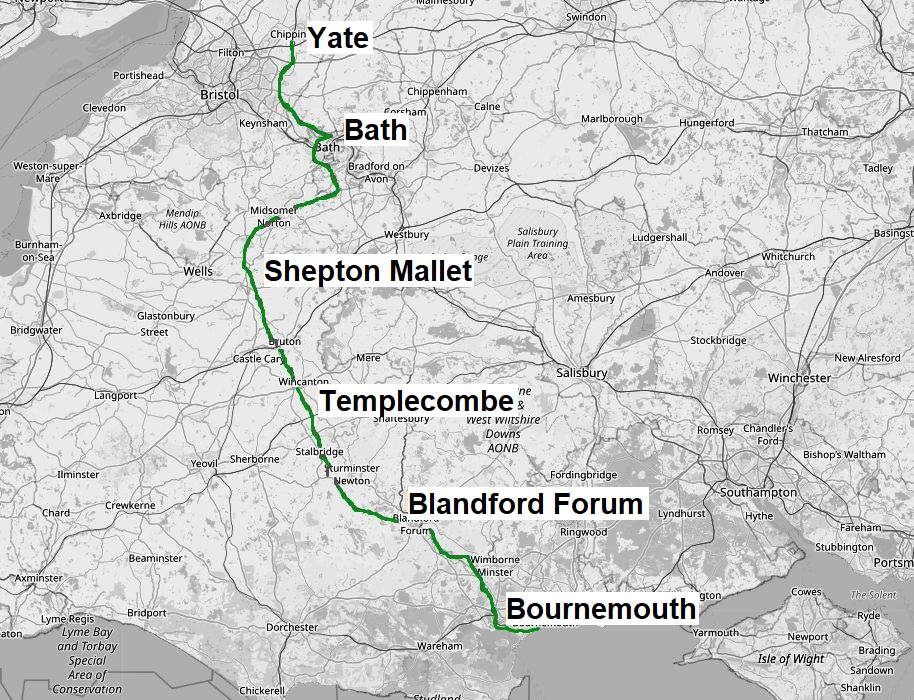
My homemade “Pines Trail” would pass through the historic city of Bath, climb over the Mendip hills, go along the banks of the River Stour and end up at the entrance to Bournemouth Pier.
It took me a couple of weeks to complete the route planning. I experimented with a few different variations and eventually ended up with a long green line drawn in marker pen on several Ordnance Survey maps. I estimated the total distance to be around 105 miles.
I should say immediately that a large proportion of my path was not original at all. As well as four long sections of cycle / walking trail built on the old track bed, I had also used parts of pre-existing named paths like the East Mendip Way, the Monarch’s Way, the Stour Valley Way and “Cycle Route 25” as part of my trail.
Still, I certainly had quite a bit of fun trying to stick all these various bits together!
Read more about the route in detail
Putting it to the test
I decided to test the route out by walking it end to end. I estimated that by moving at a reasonable speed, I could aim to do the whole thing in five days. I would begin from Yate on a Monday morning and I planned to reach Bournemouth by Friday afternoon.
My wife, who sadly couldn’t make the trip, promised to meet me at the entrance to the pier on the Friday evening and then spend the rest of the weekend in the resort with me.
Hoping for good weather, I chose a week in August, booked four night’s accommodation along the way, packed my rucksack and then bought a train ticket for Yate.
MONDAY
Yate to Monkton Coombe (20.25 miles)
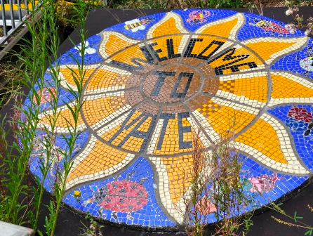
Welcome to Gloucestershire
I arrive at Yate, on a train from Bristol, at 9:59am exactly. The journey down from London has been uneventful and extremely quiet; COVID means there are still very few people travelling. I have told everyone I am off walking in Somerset and Dorset, so I feel just a bit of a fraud getting off the train in Gloucestershire. Still, I will just need to complete a modest 10 miles in this county before I cross the River Avon into Somerset.
As I am leaving the station I spot a colourful mural on the platform. A sign claims it is by local school children and it dates from 2012. On the spur of the moment I decide that my trip needs a proper starting point and this should be it. It is official: my five-day journey will be from this mural at Yate to the pier entrance at Bournemouth.
I leave the station just after 10am. This would have been the time the 1930s Pines Express used to leave Manchester. The old train would have thundered through here around 2pm and then continued towards Bath on the main line built by the Midland Railway.
The first bit of that route actually still exists today, but now it is just a branch to an oil distribution depot. The old line then ends, rather eerily, at buffer stops directly under the M4 motorway about 3 miles south of here.
I set out across Yate Common, walk past a field of goats and then along an uninspiring B-road into Westerleigh. I head through a gap between a church and a pub and onto my first footpath to climb my first little hill. I am feeling good and I am confident about the trip.

Dramway
After the M4, I begin to walk along the cycle path that has been built on the old track bed of the Midland line. I can follow it more or less all the way into Bath and beyond, but I soon make a little diversion to the east to follow the route of a much older railway: the Dramway.
As I skirt the outskirts of Bristol, this old 18th century route for horse-drawn coal wagons takes me past the old colliery at Brandy Bottom. There are a few information boards along the side of the path and there is even a tunnel from the old line.

I am still getting used to the walking. I am trying to adjust my clothing to the heat and get up to a reasonable pace. I am carrying about 8kg in my trusty old Lowe Walkabout 25. A fifth of this weight is actually water; I fear it will be needed as it is forecast to be extremely hot over the next 3 days and COVID means I can’t guarantee places will be open. I considered wearing hiking boots but I am trying out some new “Salomon X Ultra” walking shoes instead. So far they are proving a good decision.
Warm in Warmley
Soon I am back on the cycle path. This is the main route from Bristol to Bath and it is quite busy. After more than two hours walking, I come to the first station that the Pines Express would have passed on its way south from Yate: Warmley (6.8 miles). Today it is a popular stop on the path and has been restored. The old signal box is open for visits on weekends and there is a little café on the platform serving snacks. It is all tastefully done and painted in authentic Midland Railway colours.
I get a chicken and bacon sandwich and eat it in the little garden next to the platform. I chat with Lizzie who is serving the food and she tells me that she reckons that yesterday was about the hottest day she has experienced working in 10 years. Today will be even hotter though, she predicts.
Cycle Way
I usually have mixed feelings about walking along cycle trails on old railways. I am always interested by the route and the railwayana along the way but I find the paths are often surrounded by trees and the scenery can be a bit dull. Today, though, I am glad of the shade and, as it is already touching thirty, I have no complaints at all.

It can also sometimes be a bit soul destroying walking along a track as cyclists flash past often appearing to be totally oblivious to you. Here, though, everyone seems extra friendly and I am quite surprised at how many smiles or waves I get from people on their bikes.
A Spiritual home
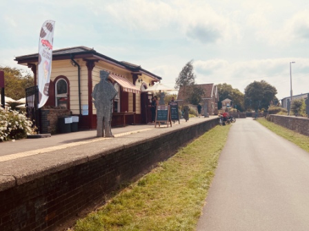
A bit further on is the next station: Oldland Common (8.5 miles) and suddenly on the left side of the path the railway is back. The track and platforms have been restored by the Avon Valley Railway who run trains between here and Avon Riverside, 3 miles further south.

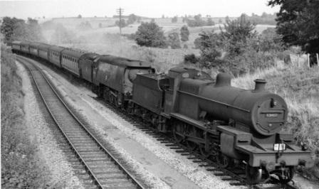
They are based at the next station, Bitton (9.15 miles), which has been extensively restored. There are no services today but the “Pines Express” dining train that they run on Sundays is in the platform complete with its authentic headboards. Although it is often associated with the Somerset & Dorset Line, the “Pines” was a creation of the LMS and it is probably here on the Avon Valley, where they are reviving the atmosphere of that railway (and its Midland predecessor), that its spirit lives on.
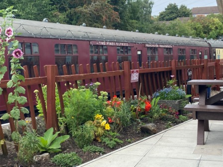
The station café is open so I get a slice of cake with a coffee and sit on the platform eating it. There are three guys hard at work restoring a carriage and a fourth is on his break on a bench close by. I sit with him and we talk for a while about my trip, the history of the old train and the restoration work.
Avon calling
I set off again and follow the preserved track until it eventually comes to an end just inside Somerset after a bridge over the River Avon. It is the first of four such bridges on the way into Bath and I stop off at each one. There is quite a lot going on down on the river; people are swimming, cooking on canal barges or just generally relaxing in the shade. It certainly looks a lot cooler down there than up on the bridges and I am quite jealous.

I pass the site of Kelston (11.6 miles) and continue on, getting increasingly hot, until the cycle path parts company with the old track bed and continues along the river bank. I follow the Avon too and then walk past the old station building at Weston (14.6 miles) as I approach the centre of Bath.

A refreshing reversal
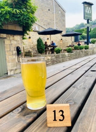
It is late afternoon by the time I pull up at Bath Green Park (15.7 miles). The building has been impressively restored and, although there is no farmers’ market today, there are still plenty of stalls selling food and drink; the place has quite a cool vibe. I feel totally exhausted as I get a seat at the pub at the far end (table service only due to COVID) and order a cool IPA.
I recover some energy and survey the scene. The Pines Express would have stopped here for just five minutes. This was always a terminus station though and all “through” trains reversed here. During the stop, another locomotive (or usually two) would have been attached to the rear end of the train ready to haul it onwards to Bournemouth.

Meanwhile, the crew that had brought the train in from the north would have been able to rest a while as they waited for their own locomotive to be released. As I sip my cold beer I try to imagine what it must have been like working on a footplate on a hot day like today.
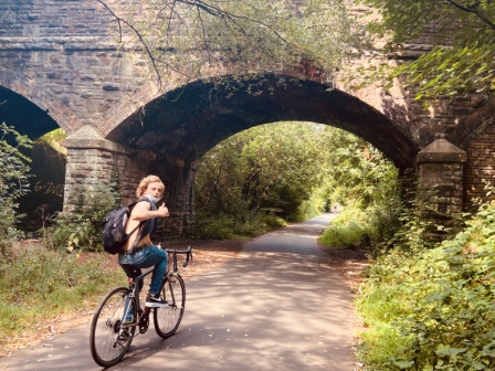
Two Tunnels Greenway
Soon I am off too. I retrace my steps for a while and then turn left, following the route of the Pines Express, onto the Two Tunnels Greenway; the cycleway that is built on the old Somerset and Dorset Joint Railway (S&DJR) track bed. This departure from Bath is uphill; it is quite a bit of a strain on me today and it was always a big challenge for the footplate crew.

At tea time on Monday the cycle path is very busy with cyclists and runners. I enjoy some nice views of the city in the distance as I climb out slowly. I eventually come to Devonshire, the first (shorter) tunnel, and inside it’s quite enjoyable with its cooler air offering a respite from the heat.

There is a sign at the entrance of the mile-long Coombe Bank Tunnel warning of reduced lighting. Sure enough, it seems vandals have been at the system and the lights on one side are all out. It makes the atmosphere inside a bit more eerie and it seems to slow me down, although maybe that’s because I am just too tired. It takes me over 20 minutes to get through and I am actually glad to emerge back into the daylight.
Monkton Coombe
I cross Tucking Mill Viaduct and then peel off the cycle track. I am now done with the main part of the trip for the day. I clamber down some steps next to the viaduct and then walk about three quarters of a mile along a quiet road into the delightful village of Monkton Coombe. It is just before 6pm, the heat is starting to wane a bit but it is still sunny; the walk is over and I am beginning to feel pleased with myself.

At the Wheelwright’s Arms, Maria quickly checks me in and directs me to my room. She tells me she is from Madrid and has been in England since February. She is here trying to improve her English but so far the lack of customers due to lockdown has left her frustratingly short of people to practice on. Tonight will be different though.
I unpack quickly and return to sit outside the bar; I order a pint of local Midford Cider (I am intending to try as much Somerset cider as I can) and choose a burger from the menu; I quickly realise the whole place is getting pretty packed.
It suddenly dawns on me that it is Monday and the “Dine Out to Help Out” UK Government discount campaign is in full swing. When Maria brings my own bill it is clear that I have 50% off too. Eventually I am forced to share my large table, but the young couple from Bath who come to sit next to me are a delight and we chat amicably for an hour or so. We exchange lockdown stories, I explain my trip and they give me the run down on their ruined holiday to Spain and their new plan for a “staycation” in Wales.
TUESDAY
Monkton Coombe to Shepton Mallet (21 miles)
Leaving Titfield
I am back on the road by 8:50am the next morning. The forecast is for another scorching hot day so I am trying to beat the heat as much as I can. The sun already feels quite strong as I pass Tucking Mill Reservoir and head back up onto the track bed above.
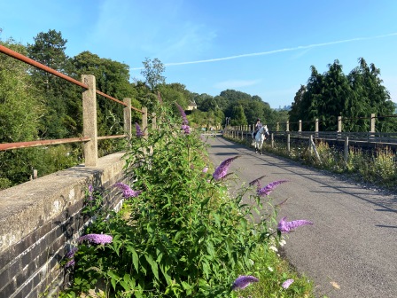
I continue along the cycle path; I pass in front of Midford Castle, walk along the old platforms at Midford (1.3 miles) and then, followed by a girl on a white horse, cross the viaduct beyond.
This viaduct featured in the opening scene of “The Titfield Thunderbolt”; the famous 1953 Ealing comedy about local efforts to save a branch line from closing. The whole film was shot in the area and Monkton Coombe actually had a starring role as the village of Titfield itself.
Mendip stones
As the Pines Express passed over Midford Viaduct it would have left the single track section it had been following since Bath. From here onwards as far south as Templecombe there would have been a track in each direction.
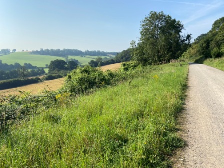
After Midford there are great views off to the left of the trail. I am now passing through the Mendips, a range of limestone hills, and for the next couple of days the scenery will continue to be, if not outstanding, very attractive.
A little further along the trail is an intriguing art work. It is a memorial to William Smith who is often hailed as the father of British geology. In the late 18th century Smith discovered it was possible to use fossils to identify strata, and he produced the world’s first geological map based on the area around here.
The memorial (Jerry Ortmans) features rocks arranged in the same way as in Smith’s 1799 book – “Order of Strata”.

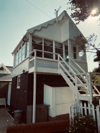
Lonely Hearts Club Signal Box
The cycle path finally finishes just before Wellow. The next bit of track bed on from here is in private hands. I meander around the village of Wellow (3.85 miles) and turn down Railway Lane, crossing the old track bed again at the point where the last surviving original S&DJR signal box still stands.
This signal box and Wellow station (just out of sight here) were owned in the 1970s by Peter Blake. He is perhaps most famous as the artist who created the cover of the Beatles Sgt. Pepper album. Apparently he used to use the old box as his studio.
A delightful little path next to the signal box takes me down to a ford and a bridge over the River Somer; then for the next hour or so I leave the old railway behind as I criss-cross fields on footpaths. Eventually I am reunited with the track bed just after Shoscombe and Single Hill Halt (6.5 miles) and I follow it once more into to the centre of Radstock.
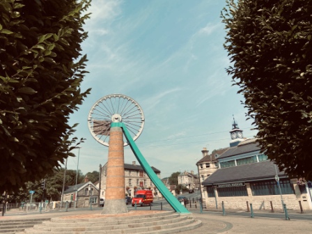
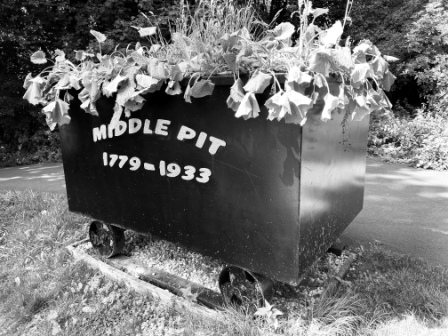
Pit stop
After passing through all this idyllic Mendip scenery, Radstock (8 miles) comes as a bit of a surprise. It is an old pit village that was once part of the East Somerset Coalfield. There is a colliery wheel memorial right where the old station used to be and a museum alongside it. The collieries around here used to provide the old railway with a fair bit of lucrative freight traffic.
I pop into the local Co-op and get a picnic and a couple of litres of water. It is getting extremely hot again so I try to find a spot in the shade to eat my lunch.
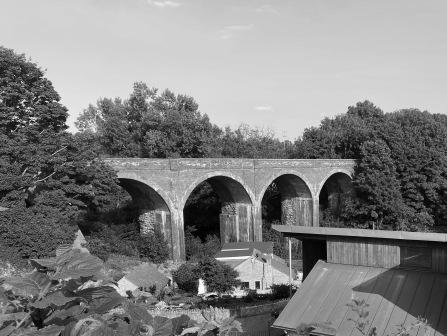
I leave Radstock, once more on the track bed, passing over the impressive old Five Arches Bridge that used to take the S&DJR over the GWR line here.
Midsomer Norton
The Pines Express would have been starting to climb hard again after passing Radstock and the gradient is perceptible even to a walker. I soon realise that I am walking quite high up the valley side with the town of Midsomer Norton visible down below on my right.

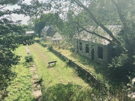
Eventually I reach the preserved station at Midsomer Norton (10 miles): home of the Somerset & Dorset Heritage Trust. There is no one about but the gate is open and I wander around the site anyway. It is quite impressive what they have managed to achieve here. The station looks just as it would have done back in the 50s and there is a mile of re-laid track stretching south.

I continue walking by cutting through the Silver Street Nature Reserve and then I find myself on a path alongside the preserved line. I walk with the track on my left, the gradient is still quite steep and the views off to my right are getting more impressive.
Eventually the rails come to an end before Chilcompton Tunnels. The approach cutting has been filled in, so I am forced to leave the formation and climb over the hill on a footpath and a road. I rejoin the line on a path just south of the tunnels and continue on through to Chilcompton (12 miles).
Going off the rails
From here onwards, and for much of the rest of the way to Shepton Mallet, the track bed is no longer accessible. I take off in a slightly different direction heading over fields and then along an enchanting bridleway through a dense wood. I get the impression no one has been this way in months and it feels all the more magical believing that.

I emerge near Binegar (15.1 miles) and walk past the old station site before catching last orders at the Horse and Jockey just before 3pm closing time. The beer, which I enjoy in the pub garden, is welcome but it is getting warmer and warmer and I have to plan well in order to conserve water.
I am near the summit of the line now and after a few more miles in the hot sun, I stand on a bridge overlooking Masbury (17.9 miles). The station building here is one of the better preserved ones, but it is privately owned so the closest you can get is a glimpse from above.
Supersonic
The last three miles on to Shepton Mallet are really tough. I go across country again and get lost on footpaths a couple of times. I blame the farmers for letting the stiles become obscured by bushes, but deep down I know this is probably rubbish.
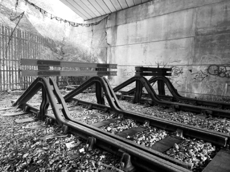
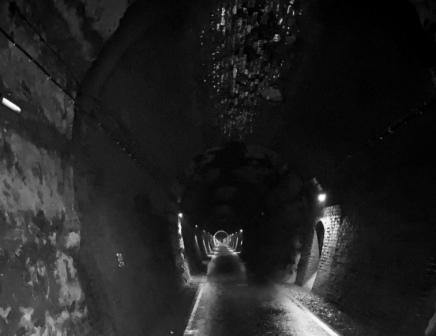
My pace is a lot slower and it seems to take ages to get to Windsor Hill. The two tunnels here are hidden from view and fenced off, but until recently they were accessible and could be walked through. Just after the line closed one of them was actually used to test a Rolls Royce Concorde engine!
I clamber down an embankment on what is supposed to be a footpath but actually just seems to be a forest of gorse bushes. I get a few cuts and scratches but eventually I find a way through and emerge back on the old formation; the town of Shepton Mallet is now just in front of me. It is a relief but even this last little bit seems like a big challenge.
Babycham
On the way into Shepton Mallet I pass the vast Showerings Cider Works and just outside I spot a large model of the Bambi-type character used to advertise Babycham. The drink, which is a sparkling Perry, was invented here in the early 1950s and became very popular over the next twenty years.

The railings make it appear as if the little deer has been incarcerated. Perhaps it is not all that unintentional because Shepton’s other big claim to fame is its prison. The jail, right in the middle of the town, is famous for housing the Crown Jewels during the war as well as numerous famous criminals, including the Kray Twins, since. It is a museum now and the guided tours that the former guards give around it have a good reputation.
The Dusthole
Shepton seems like a lovely little town but I am not really in the mood to do it justice. I am still feeling a bit hot and bothered when I finally locate my lodging, the Dusthole (also known as the King’s Arms), just around the corner from the prison.
The last thing I need now is an enormous black dog barking at me and blocking what I think is the entrance. Eventually a woman appears, calls the dog by its name, Tyson, and directs me to another door hidden behind some wheelie bins. I am expecting the worst as Tony, the landlord, checks me in. I suspect somehow this is not going to be a great stay.

I couldn’t be more wrong. The whole Dusthole experience is an absolute delight. My room is nice and cool but, as Tony explains, the bar is even cooler. Soon I am sat with a pint of Somerset Pig cider in my hand chatting with Tony and a couple of other guests. Tony certainly knows a thing or two about running a pub and his homemade fish (in cider batter) and chips is absolutely delicious too. I want to say it is worth walking 21 miles for, but my feet won’t quite let me.

Over more cider and beer, I get the whole rundown on the pub’s history (it is 400 years old) and the story of how Tony took it over 20 years ago and renamed it. Nobody in the town ever called it the Kings Arms, he explains, so we just formalised the nickname and it is now the Dusthole.
I get a lesson in Somerset slang including “How be on? (How are you doing?) and “Where you to?” (Where are you?). I get to listen to Tony’s fascinating tales of his travels around the world and I also hear all about the latest challenges of running a pub and hotel during COVID-19.
All in all, I really couldn’t wish for a more pleasant place to spend an evening. Even Tyson turns out to be a bit of a sweetheart!
I have the best sleep I have had in months and wake up almost ready for another 20 miles!
