Thursday, 28th July 2016 – Edale
We journeyed up to Edale by train changing at Sheffield en route. We arrived in the late afternoon just as it was beginning to rain! That was an ominous sign!
We checked into the Rambler Inn and set off about half a mile down the road to have a pint at the Nag’s Head and to check out the official starting point of the Pennine Way.
With the rain still pouring down, we returned to the Ramblers Inn for a hearty meal and an early night.
PW Day 1 (Trip 1 – Day 1)
Friday, 29th July 2016 – Edale to Cowden – 16 Miles
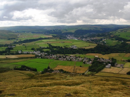
We woke the next morning to grey skies and mist on the hills. Unperturbed we returned to the Old Nags Head and paused for the obligatory “we are at the start of a long walk” photograph and then set off immediately.
For a trail that goes over some wild hills and that has a reputation of being very tough to tackle the Pennine Way starts rather sedately. It creeps gently along fields, around the base of a hill and along a rather wide and easy going path.

The nice easy stroll with lovely views doesn’t last long however and soon we arrived at the foot of Jacob’s Ladder. The ladder is named after an 18th century farmer called Jacob Marshall.
The ladder is steep. Almost on cue, just as we began to climb, the heavens opened and for the next two hours it poured with rain.

The ladder is only the very first little bit of the long heavy climb up Kinder Scout; the highest point in the Peak District. The Pennine Way has now been diverted to avoid the summit and travels around the edge of the plateau via Kinder Low instead. “Low” is a misnomer as the summit (2,077ft) is only slightly lower than the main peak itself.
By the time we got close to the top of Kinder Low the mist on the top had thickened. At times we were almost struggling to see where we were going. The Pennine Way was living up to its fearsome reputation already.
The view off to the left was supposed to be spectacular. We couldn’t see anything. It was misty and raining and my mobile phone had just completely ceased to work. It was all a bit miserable and one could be forgiven for wanting to return immediately to Edale and get the first train home.
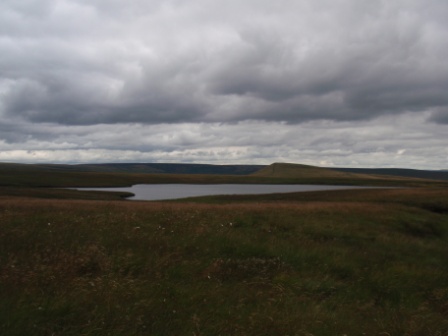
We pushed on in search of the next way point; a waterfall known as Kinder Downfall. After another few minutes we found the waterfall and that is where we first met Colin. Colin introduced himself as he peered down taking a picture of the water in the mist.
We had a break and chatted to him for a while. Colin was from Luton and was in his early 20s. He had just graduated from a college and he was due to start work in September. He was spending the next 18 days tackling the whole Pennine Way on his own.
When he told us he would be rough camping and carrying all of his supplies the whole way, my first reaction was one of deep admiration. But when he mentioned that he had never done anything like this before and had no real practice walking, I began to pity him. When I noticed he was wearing thin training shoes and it was clear that his pack was far too heavy, I began to question his sanity. He was clearly asking for trouble.
We moved off and Colin, slowed down by his heavy pack, walked just behind us. We crossed the River Kinder near the downfall but immediately lost the path on the other side of the stream. Colin and my wife waited whilst I clambered around in thick heather trying to find it again.
I was going roughly in the right direction but I was in thick heather and without a proper path. Luckily I saw some walkers coming towards me in the mist. Even luckier one of them had a GPS and she confirmed I was heading in the right direction. We found the proper path further on.
With Colin and my wife back in the group, we followed along the edge of the moor for another mile as it descended out of the mist first gradually and then steeply to the Ashop Clough Col.
From the Col we headed sharp right and headed up the lonely and drab moraine ridge of Mill Hill and onto Featherbed Moss. This is peat bog country; it is very damp and nasty but at least there are paving stones. The whole two and a half mile stretch was featureless and sloppy with the paving stones squelching in the peat as we walked over them.
By this time Colin was complaining about the weight of his pack almost constantly and my wife was busy offering suggestions for reducing weight.
The main Snake Pass (A57) road was visible long before we reached it, but it still seemed to take forever to get to it. Eventually we did reach it and sat down immediately to enjoy our sandwiches. It wasn’t the most picturesque lunch spot but it was a good point to break our day’s walk. The journey over Kinder was behind us and the journey over Bleaklow just ahead of us.
After a suitable rest we set off up towards Bleaklow Head. The path follows a clough (stream) for the first part of its journey up the hill and then later on the path basically merges with the stream. The going is extremely rocky and wet. Thankfully we had sturdy boots and waterproof clothing.
Suddenly Colin, still trailing behind us, let out a terrifying yell and slumped to the ground. He had twisted his ankle. Actually, he had twisted his ankle quite badly. He tried to walk on it but he couldn’t and he just slumped to the ground again in tears.
Given his choice of footwear and the terrain we were walking on the injury was hardly a surprise. Nevertheless, it gave us a big problem. We could hardly abandon him yet there was no telling how long it would take him to get down.
Fortunately we were very close to Bleaklow Head at this point, and so with a bit of encouragement and help from walking poles we eventually managed to get him mobile again. Together we reached our second summit of the day (2,077ft). At least we knew it was going to be all downhill from here.
We paused for the obligatory photo, but given that it was getting very misty again we didn’t want to linger up there for a minute longer than necessary. We decided to push on as best we could.

Coming off Bleaklow Head is known as a bit of a navigational hazard. All the guidebooks point this out so I had come prepared with enlarged maps and even photographs. Fortunately it was easier than expected and keeping an eye on map, then compass, then map, then compass, I managed to find the beginning of the path that would take us down Torside Clough.
Colin had started to move a little better by this point although he had become despondent about his chances of making it into a second day let alone to Kirk Yetholm. We had drastically reduced our pace and he hobbled along behind us.
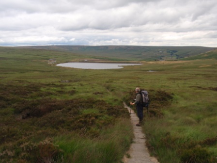
Finally Clough Edge came into view and the weather brightened up again as we descended. We followed the path down towards Torside Resevoir below. With many stops to help Colin recover it would be a while before we actually made it down to the water’s edge.
The heather was quite beautiful but the little ledge path was quite narrow with some sheer drops off the right hand side. Colin hobbling along and swaying under the weight of his pack worried us a few times. We both had visions of him toppling over the edge never to be seen again.

Happily he was fine and eventually, probably almost two hours later than we had planned, we all made it down to the road that skirts the southern part of Torside Resevoir. Colin was very relieved and promised us he would spend a night in the local campsite and then head back home the following day. We never encountered him again so we assume he did just that.

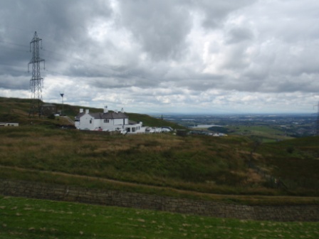
Meanwhile I had made a call to our lodgings for the night, The Windy Harbour Hotel, on the outskirts of Glossop. It is about 3 miles west of the trail, but the owners get a lot of business from walkers and so operate a taxi to and from the hotel. A few minutes later a 4X4 turned up and within ten more minutes I was sitting, pint in hand, in the lobby of the hotel.

The food at the Windy Harbour was basic home cooking. It was nothing fancy but it certainly did the job. After “chicken in cream sauce and vegetables” and another pint I was ready for bed.
PW Day 2 (Trip 1 – Day 2)
Saturday, 30th July 2016 – Cowden to Standedge – 11 miles
Looking out of the bedroom window we were glad to see that Saturday’s weather looked a lot more promising. After a satisfying breakfast we prepared to set off again. Whilst we waited for our driver to finish his other chores we watched the staff of Windy Harbour carrying flowers in from vans as they prepared for a wedding later in the day. Our driver finally appeared and in no time at all we were back once again at Cowden Reservoir on the Pennine Way.


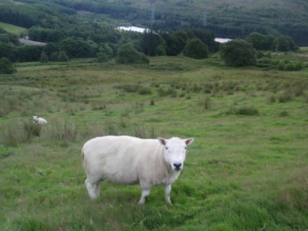
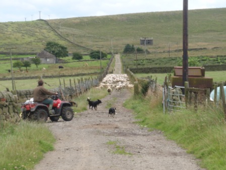
After crossing the reservoir on the dam we walked along the path on its northern edge eventually crossing into sheep-filled fields.

From there we turned into Laddow Valley and headed along the path gaining height gradually up the left side and along a ledge above Laddow Rocks.

The path wound its way along the narrow ledge and at times it was a little too narrow and precarious for comfort.


Soon we were descending again and as we got lower the ground turned boggy. It was very boggy. This is the notorious Black Hill and the many peat bogs in the area were the nemesis of earlier Pennine Wayfarers. Happily the authorities have laid a magic carpet of paving stones across the worst bits and today one can only imagine what it must have been like ploughing through without them.
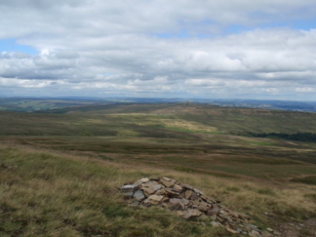
After a long slog we made it to the top of Black Hill (1,909ft) and enjoyed our sandwiches there admiring the view.
Snoopy’s snack van on the A635 near Wessenden Head is something of a Pennine Way legend. Apparently the purveyor of the best bacon butties in the UK, the little white van appears every morning at the lay-by and stays until mid afternoon. We could see Snoopy way in the distance as we descended Black Hill. We hoped that he would stay just a bit longer that day so we could get a warm drink on the way past. Just as we were getting close to Snoopy our hearts sank as we watched him pack up bang on schedule at 2pm and drive off in the direction of Sheffield.
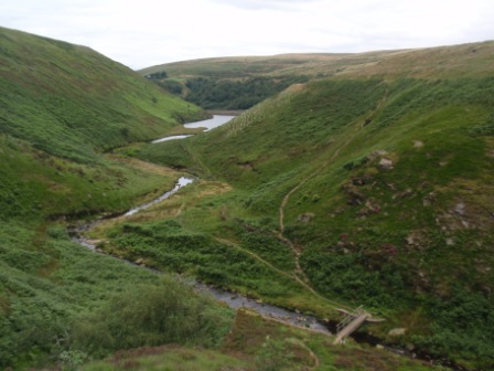
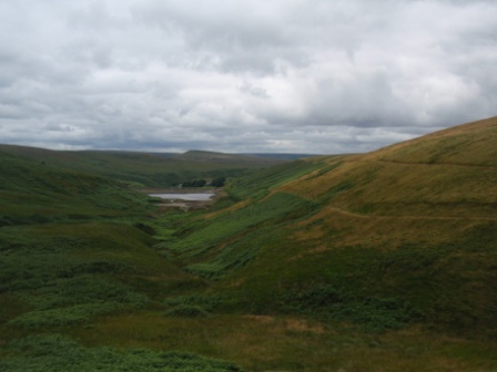
Moving on across the A635, sadly without a hot drink inside us, we continued to descend down towards Wesseneden Reservoir and then on the level along the edge of the water. We could “smell” Marsden, the goal for the day just ahead and we were feeling good.
But the Pennine Way had a nasty surprise for us. At the end of the reservoir the path crossed a ford and then bent back on itself up a long steep and totally knee-aching incline.
That route took us up Blakely Clough and eventually on to Black Moss. We were now heading frustratingly away from Marsden. We twisted and turned for a few more miles on the top walking past Black Moss Reservoir and then Swellends Reservoir. Both of these were built in the 18th Century as part of the works for the Standedge Canal Tunnel. The Tunnel and its three parallel railway counterparts were directly below us as we approached the main Manchester-Huddersfield road at Brun Moor.

The Pennine Way continues over the A-road and on into the distance but the walker in need of accommodation is forced to descend either left into Diggle (Manchester side) or right into Marsden (Huddersfield side). Fortunately the frequent Manchester- Huddersfield bus runs right past this spot and there is a stop at Brun Moor in the perfect place. Bang on schedule the 184 bus arrived and 10 minutes later we were standing outside our hotel for the night; the New Inn at Marsden.

Marsden is a lovely little village and it looked especially pretty in the evening sunshine. We went for a walk looking for an evening meal but, it being Saturday night, we found everywhere crowded or fully-booked. We were too tired to care and eventually we settled for a room picnic assembled from items purchased at the local Co-op. Most of them were cold but there was a warming Pot Noodle in there. I slept soundly and dreamt of peat bogs.
PW Day 3 (Trip 1 – Day 3)
Sunday, 30th July 2016 – Standege to Hebden Bridge – 15 miles
The next morning, after a superb breakfast at the New Inn, we caught the bus back to Brun Moor on the top of Marsden Hill.
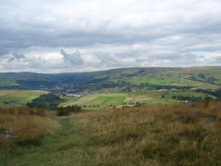
Our first stretch of Pennine Way of the morning took us along Milstone Edge. The weather was really brightening up and we had excellent views to the west of Greater Manchester and far beyond towards Liverpool and Wales.
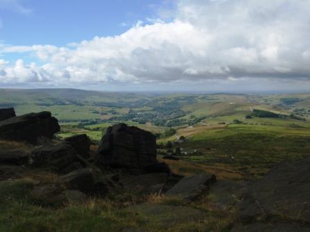
The scenery was changing at last from the peat moorlands of the previous two days to a much friendlier landscape.
The next stage of the walk had us climbing up to the summit of White Hill (1,528 feet), passing en route into Lancashire (the PW stays in Lancashire for about 5 miles) and encountering the most easterly part of Britain’s best county.
After descending White Hill we quickly passed over the M62 on the rather stunning pedestrian bridge. It was built especially for the Pennine Way when the motorway opened in the 1970’s. The motorway is at his highest point here and the bridge carries the path 65 feet above the road surface.

Once over the motorway we carried on climbing to the trig point up at Blackstone Edge (1,549 feet). We had our first morning break at the top of Blackstone. We rested whilst chatting to a man accompanied by his dog. He was a really interesting character: A Lancastrian who could have been from central casting. He was long retired and took his dog out for a moorland walk almost every day. One of his twin daughters would drop him off and the other would pick him up. Later in the year he was scheduled to resume his own attempt at completing the Pennine Way.

Descending down Blackstone Edge we were met with a very pleasant sight; the A58 stretched before us and situated just off it was the White House pub. The pub was originally opened in the 17th century and has been in business ever since. Surely no thirsty walker could refuse its inviting bar?
Certainly not this one. As we arrived at the pub they were just getting ready for Sunday lunch. People still dress up more for meals out in the North and it was quite a nice atmosphere. Sadly we had no time for lunch but we did manage a pint. It went down a treat.
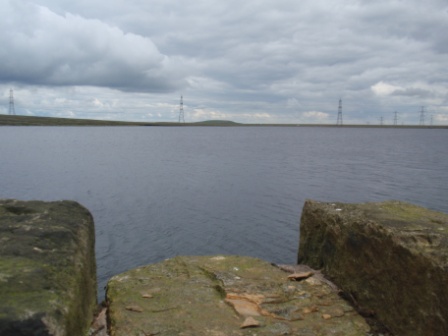
After the White House it all got a bit flatter and more crowded. We mingled with a lot of day trippers and dog walkers as we walked past Blackstone Edge Resevoir and White Holme Resevoir. Eventually the route led to the grand-sounding “Todmorden Centenary Way” along the edge of Warland Resevoir. All these resevoirs were built in the late 19th century to supply the residents of Oldham and Rochdale with their drinking water.
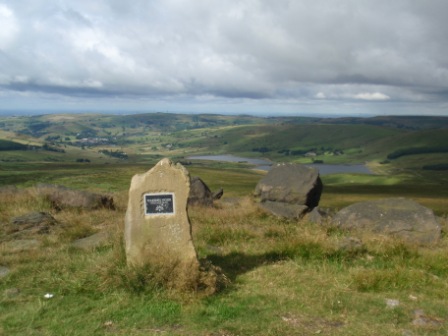
Finally, leaving the reservoirs behind, we headed up Coldwell Hill and stopped for our picnic lunch. We ate our sandwiches whilst sheltered behind some rocks enjoying the beautiful views across to Todmorden.
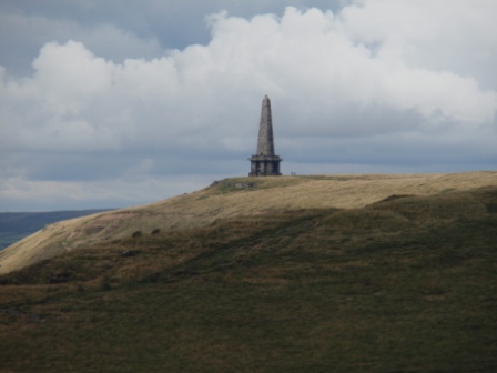
Leaving Coldwell Hill we descended a little and then ascended some more and soon we were on top of Stoodley Pike. By itself Stoodley Pike isn’t that impressive a hill, but what makes it stand out from its neighbours is the large monument stood on its top. The monument even makes it on to some of the logos for the Pennine Way itself.

The monument celebrates the surrender of Bonaparte during the Napoleonic Wars. The great thing about it is that you can go inside. That is exactly what I did. The 39 steps took me up to a small viewing platform 40 feet above the ground. The staircase wasn’t lit so much of the climb up was done in the pitch black. it was lots of fun.
Stoodley Pike had been our last peak of the day and coming down we were in quite a celebratory mood. The track led us down through farmland and eventually into Callis Wood.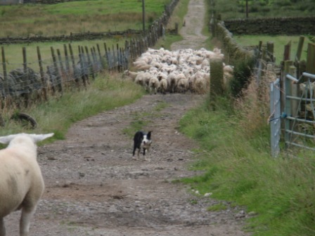
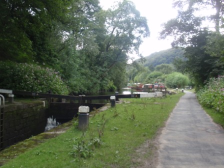
After a lot of steep downhill work we finally reached civilization at Callis Bridge on the Rochdale Canal on the outskirts of Hebden Bridge. The Pennine Way doesn’t get too close to the centre of the town so we abandoned it (until next time) at a sign post just where it crosses the main A646 road.
We then headed off for a mile or two along the beautiful (and flat) canal to the picturesque town of Hebden Bridge. We caught the train home from its impressively-restored station resplendent with hanging baskets.

For 2016 at least, our Pennine Way journey was over.

