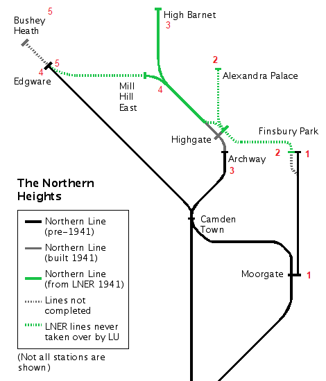
Following unfinished sections of the Northern line towards Alexandra Palace and Elstree.
Taken at the London Transport Museum in Covent Garden, the image below is of a 1938 tube train. The destination blind of the train is photo-shopped: it shows a route that was due to open in Autumn 1940 but never did. Had it not been for World War Two, it would now have been possible to catch the Northern line from Moorgate to Alexandra Palace.
Another planned route, due to have opened in 1941, would have extended the Northern line out to Bushey Heath on the outskirts of Watford.

Both the Alexandra Palace and Bushey Heath projects were part of the 1935-1940 London Transport “New Works” programme. The scheme was financed by government-backed loans and guided by London Transport’s inspirational CEO, Frank Pick.
The aim was to meld together existing tube lines, older LNER steam-operated railways, and new construction to create a much-enlarged Northern Line. The scheme is often known as the “Northern Heights” and although it was not totally unsuccessful, the outbreak of war meant that much of it never happened.
A lot has already been written about the history of the Northern Heights project. My own modest account, together with a list of sources I have used for information, is here.
My Plan
In late spring 2021 I planned a series of 5 walks to visit all the stations (past, present and proposed) related to the Northern Heights scheme.
My trips would include walking between the stations of present-day tube lines, trekking along the track bed of old railways, and hiking across countryside where trains were once destined to run.
I am a big fan of urban walking and I find that London, even in its outer suburbs, never fails to disappoint. Walking between stations is a good way of seeing them in the context of the areas that they serve.
The initial service pattern that the enlarged Northern line would have offered in 1941 is detailed on Wikipedia. I have referred to it during all my trips to illustrate the sort of service each of the stations would have had if the whole plan had been implemented. For clarity I have described the proposed service in the northbound direction only.
As well as offering much of railway interest, the walks also led me past a variety of fascinating sites, not least several that were connected with the British TV and film industries. These included one of London’s best preserved old cinemas, the building from where the world’s first regular television service (1936) was broadcast and the studios where Star Wars and many other famous films were made.
The 5 Walks
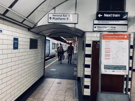
Walk 1 (Moorgate to Finsbury Park) is detailed below.
Links to the other walks are here:
Walk 2 – Finsbury Park to Alexandra Palace (4.4 miles)
Walk 3 – Archway to High Barnet (8.3 miles)
Walk 4 – Finchley Central to Edgware (4.5 miles)
Walk 5 – Edgware to Elstree & Borehamwood (6.6 miles)
An Overview Map
The map below is a very useful overview of the Northern Heights plan and I have added the start and end points of each of my walks to it.
Walk One
Moorgate to Finsbury Park (3.6 miles)
Although it has a slightly looser connection with the “Northern Heights”, this walk along the surface over the underground line that links Moorgate with Finsbury Park is quite rewarding. It is the shortest of the five, but it can easily be combined with Walk 2 for a longer day out.

Note – On the map above the route is shown in green.
To start, get an Oyster /Travel Card that includes at least Zones 1-2 and get yourself to Moorgate Station.
Moorgate (1865) would have been linked to new destinations because of the Northern Heights plan. It would have become the starting point for 7 trains an hour to Alexandra Palace and 7 to Finchley Central (extended to High Barnet in the rush hour). There would also have been 14 peak hour shuttle trains an hour to Finsbury Park.

These services, up to 28 an hour in the peak, would have used the two deep level terminus platforms opened by the Great Northern and City Railway (GN&CR) in 1904.

The GN&CR was the third railway at Moorgate; the Metropolitan Railway (today’s Metropolitan line / Circle line) had first opened the station in 1865 and the City and South London Railway (the precursor of today’s Northern line) had arrived with their own tube in 1900.
Although constructed using “tube” methods of construction, the GN&CR’s line to Finsbury Park was built for mainline sized trains. The line passed to the ownership of the Metropolitan Railway in 1913 and thence to London Transport (LPTB) in 1933. A few years later, in preparation for its role in the Northern Heights project, it became part of the Northern line.
When the Northern Heights plan was cancelled after the war, it remained part of the Northern line, and even though there was no longer any plan to make a physical connection to the rest of the line, it continued to use small “tube” trains.
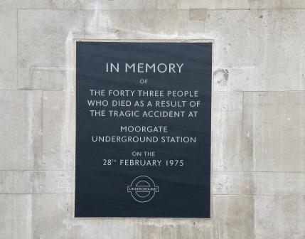
Sadly, the combination of small train and larger tunnel was a factor that made the infamous Moorgate disaster of early 1975 much worse. 43 people were killed when a crowded morning rush hour train failed to stop at the terminus and smashed into the dead- end tunnel wall beyond. The cause for driver’s failure to stop remains a mystery.

Ironically, even before the accident happened, the transfer of the line to British Rail had already been agreed and was planned for the following year. Since 1976, full size trains have operated from the two former GN&CR platforms at Moorgate to destinations such as Welwyn Garden City and Hertford East. In 2021 services are operated by Great Northern and there are up to 12 trains an hour in the peaks, 8 off peak and just 4 on weekends; not quite the frequency planned for 1941.
On the surface, we will now follow the path of the GN&CR line as it heads north from Moorgate to Finsbury park.
Turn right from the station and walk north along Moorgate itself. The road soon turns into City Road. On the righthand side is Finsbury Square. Pause for a moment to inspect the memorial to the victims of the Moorgate crash.

Continue along City Road passing the entrance to the Honourable Artillery Company headquarters. The regiment is the oldest in the Army and there is a (by appointment only) museum on the site.

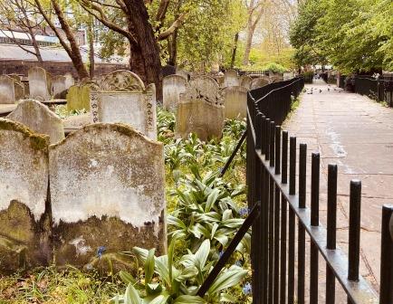
Soon afterwards is Bunhill St Burial ground on the left. It is a great place for a quiet little wander; Daniel Defoe is among the famous people buried there.

On the other side of the road here is Wesley’s chapel. It was opened in 1778, and built for John Wesley, the founder of the Methodist movement. The site is still a place of worship and the Museum of Methodism is in its crypt. John Wesley’s House is next to the chapel.

A short distance further on is the roundabout where City Road meets Old Street. Known sometimes as Silicon Roundabout, the area is famous for its cluster of web businesses. Google, Facebook, and Microsoft are some of the larger companies to have offices here.

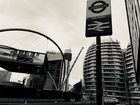
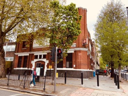
The entrances to Old Street station are in the centre of the roundabout (0.5 miles).
If the Northern Heights plan had been implemented, Old Street (1901) would have had the same service as Moorgate with trains heading towards Finsbury Park and on to Alexandra Palace, Finchley Central and High Barnet.
A station here was first opened by the C&SLR (today’s Northern line) in 1901 and the line that we are following (the GN&CR) arrived a few years later in 1904. Although each railway had a pair of tube platforms at Old Street with linking tunnels for passengers to transfer, there was never any track connection between them. There used to be surface buildings at one time, but they have all been removed and the main station concourse is below ground.
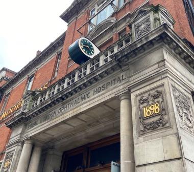
On the other side of the Old Street roundabout continue along City Road, passing Moorfields Eye Hospital (look out for its interesting eye-shaped clock) on the left-hand side. Turn right here onto Provost Street and then bear right into Vestry Street and follow it into East Road.
The road curves until it joins New North Road. Follow New North Road as it passes Shoreditch Park. Make a short diversion into the park.

On the north side of the park is the Gainsborough Building. Film studios were at one time located here in an old power station that had been built for the GN&CR but made redundant after the merger with the Metropolitan Railway. Hitchcock made films, including “The Lady Vanishes” here in the 1930s. Today it has been extensively rebuilt into apartments.
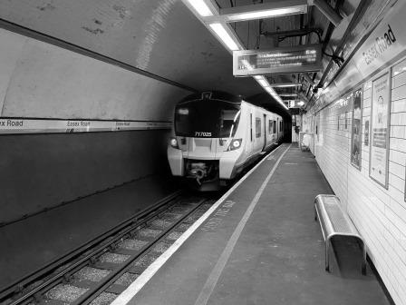
Go back onto New North Road and follow it as it crosses the canal. After some distance, New North Road intersects with Essex Road and the station building can be seen ahead on the left. (1.7 miles).
Like Old Street, Essex Road (1904) would have had the same intensive service from Moorgate with trains heading towards Finsbury Park and on to Alexandra Palace and towards Finchley Central.
The station opened with the rest of the GN&CR line in 1904. Today it is unique as it is the only “tube” station in London that is not under the control of Transport for London (TfL). The station is managed by Network Rail and the only services it offers are those operated by Great Northern.

The station building is pretty nondescript, but it is worth popping in and taking the lift down to the platforms. It is quite often very quiet and as you walk through musty, white-painted tunnels to the platforms it can feel a bit eerie. It is easy to get an idea of what the line would have been like when it first opened as Essex Road is the most unchanged of all the GN&CR stations.
On the other side of Essex Road, New North Road becomes Canonbury Road. Follow Canonbury Road past the Myddleton Arms pub. It is named for Hugh Myddleton who was the creator of the New River which can be seen just opposite.
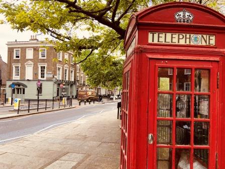
Continue to follow Canonbury Road as it passes through Canonbury Square. The Estorick Collection of Italian Art is housed in a beautiful Georgian building on the corner and is worth a look.
Canonbury Road eventually ends at Highbury Corner. A V1 flying bomb hit this busy junction in 1944 and there is a memorial to the 26 people who died on the wall.
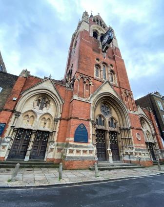
Built in the late 19th century in the Gothic revival style, the Union Chapel is also close by and worth a little diversion.
Highbury and Islington Station is on the opposite side of Highbury Corner (2.2 miles).
Highbury & Islington (GN&CR 1904) would also have had the same service from Moorgate as the previous two stops. Trains would have towards Finsbury Park and on to Alexandra Palace and Finchley Central.
A station was first constructed here as a halt on the North London line (today’s London Overground) in 1850. The GN&CR arrived in 1904 and built a completely different station on the surface with two tube platforms down below. The old entrance building still exists, but it is no longer used.

When the Victoria line opened in 1968 a new common entrance for both lines was created along with two more tube platforms alongside the GN&CR.
The approach tracks for both lines were altered so that a useful cross-platform interchange could be provided in each direction between them. The old 1904 platforms now host the Moorgate-bound GN&CR line and southbound Victoria line. The 1968 tunnels have the diverted Finsbury Park GN&CR line alongside the northbound Victoria line.
The entrance to Highbury Fields is visible from in front of the station. Enter Highbury Fields and cross the park towards the exit where Ronalds Road meets Highbury Crescent.

Exit the park and walk along Ronalds Road until the junction with Arvon Road. Turn right into Arvon Road and walk along it until it ends at a T-junction with Drayton Park. Drayton Park Station is opposite just to the right (2.7 miles).
In the peak, up to 28 trains an hour would have arrived from Moorgate at Drayton Park (1904). 14 of these trains would then have followed the original 1904 route to the next station, Finsbury Park, and terminated there. The other 14 would have followed a new route.
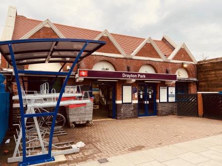
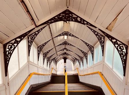
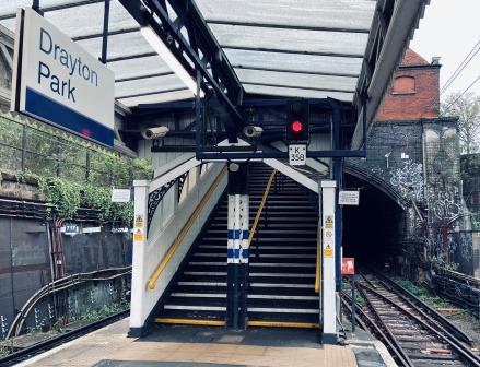
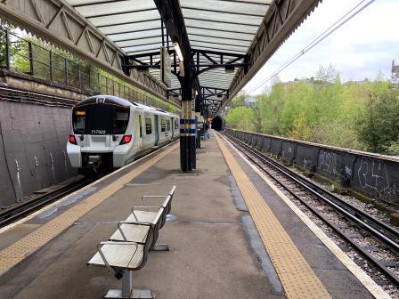
Drayton park is where the GN&CR, in tunnel from Moorgate, finally came to the surface. It is worth going down the attractively restored staircase to the narrow platform for a look.
The tunnel mouth is at the south end of the station. Northbound trains heading from Moorgate come out of the tunnel and stop. The electrical system is changed here from the third rail 750dc used from Moorgate to the 25kv AC overhead line for the onward journey.
Trains then exit the station and follow a path under the East Coast Main line up to the most westerly platform (8) at the next stop: Finsbury Park. Trains coming in the opposite direction usually come from the most easterly platform at Finsbury Park (1) into Drayton Park.
Whilst the arrangement looks permanent now, these links were only created in 1976 and were not there for the first 72 years of the station’s existence.
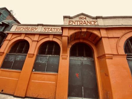
Before the GN&CR opened the line in 1904, the original intention was to link to Finsbury Park so that it could serve destinations further north (just as the Great Northern Trains do today) on the main line after Finsbury Park. This was, in fact, the reason why it had built its tube from Moorgate to accommodate full-sized trains in the first place.
However, due to a disagreement with the company that owned the main line at the time, the Great Northern Railway (GNR), it was prevented from ever creating the link.
Instead, it was left with no option but to bore tunnels from the north end of Drayton Park station for a short distance and then terminate its line underneath the main GNR station at Finsbury Park, thus forcing its passengers to change to the GNR trains above. These tunnel portals have now been filled in and buried but they would once have been visible from the north end of Drayton Park’s platform.

The Northern Heights plan in the mid-1930s again called for the installation of a link to take the tube trains from Drayton Park up to the surface at Finsbury Park. In contrast to the original 1904 proposal (and the eventual 1976 solution) which had fed the up and down lines to separate sides of Finsbury Park, the 1930s plan called for both tracks to rise together staying on the east side of the main line.
In the 1941 timetable plan, 14 trains would have used the new link, with 14 trains in the peak continuing to use the tunnels to the lower-level terminus at Finsbury Park.
Personally, I wonder if these extra 14 Moorgate-to-Finsbury Park peak shuttles would really have been necessary and whether they would eventually have been abandoned and the tunnels closed.
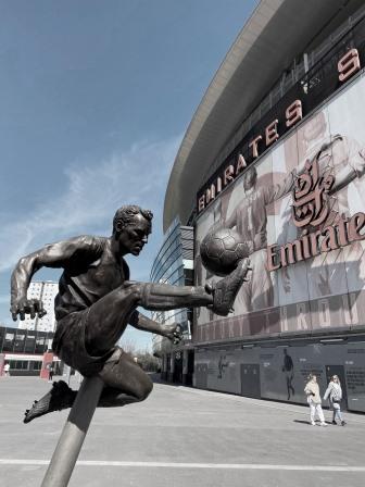
Leave the station and continue north along Drayton Park. The footbridge to Arsenal’s impressive Emirates Stadium is on the left. It worth a slight detour to circle it and perhaps even visit the shop and museum. In what could be described as an “only-in-Britain” decision, Drayton Park station is actually closed on match days to prevent overcrowding on its narrow island platform. It is not as if there is not space to enlarge it either.

There used to be an extensive network of goods sidings around here. The stadium is partly built on railway land. The GN&CR line also had their little depot next to the station at Drayton Park.
Just before Drayton Park turns into Gillespie Road turn left into Gillespie Park Nature Reserve. Follow the footpath north with the East Coast Main Line railway now visible through the fence on the left-hand side.

We are now following two separate routes to Finsbury Park. The original 1904 tunnels are below us, whilst the new 1930s tracks would have been visible here as they climbed from Drayton Park. First, they would have been beside us, but as we approach the end of the little park we would have been walking along the track bed.
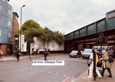
The path eventually ends at a narrow flight of steps. Descend the steps and emerge onto Seven Sisters Road. If you glance around, you can see that you have descended the middle of an old bridge abutment. This is the abutment for the bridge that would have carried the new Tube route from Drayton Park into Finsbury Park.
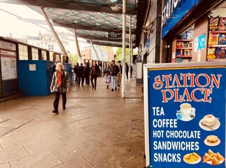
Directly opposite is Station Place at Finsbury Park (3.6 miles).
Finsbury Park (Surface 1861 / Underground 1904) Finsbury Park is the first station out of King’s Cross on the East Coast Main line to Peterborough and York. The surface station was opened in 1861 about 10 years after the line itself.
If the Northern Heights plan had been fully implemented, the Northern line would have had two different sets of platforms at this station. Two of them would have been newly constructed on an elevated structure at the east side of the station where Station Place is now.
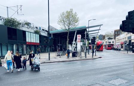
In the late 1930s work began on these new high-level platforms at the east side of the station and by 1939 significant progress had been made and the basic metal structure was almost complete. After the post-war cancellation of the scheme the structure remained in front of the station until the 1970s when it was finally turned down.
In more recent times a large canopy has been erected in front of the station in the same position and at roughly the same height as the platforms would have been. Walking underneath it now, it is relatively easy to imagine staircases and escalators leading up to the new tube station above.
It would have been from these platforms that the 14 trains an hour heading from Moorgate towards Alexandra Palace, Finchley Central and on to High Barnet would have departed.

Meanwhile, as we have already seen, back in 1904 the GN&CR had been forced to terminate its tube line from Moorgate underneath the main station. It opened a pair of platforms (at a relatively shallow depth) there and began to operate its simple shuttle service to and from Moorgate.

In 1906 the Great Northern, Piccadilly and Brompton Railway (GNP&BR) constructed another two tube platforms alongside. This railway eventually became the Piccadilly line and was extended to Cockfosters in the early 1930s.

The Northern Heights plan had called for no alterations to the existing GN&CR platforms, so they continued in use throughout. After the scheme was finally cancelled, the old line, now known as the Northern line (Highbury branch), continued as it had done since 1904.
When the Victoria line was being planned in the early 1960s it was decided to use the old GN&CR platforms at Finsbury Park for the new service. In 1964 the line from Moorgate was truncated at Drayton Park.

Meanwhile, the tunnels between Drayton Park and Finsbury Park were plugged and the Victoria line was then constructed using their old terminus platforms. By altering the access tracks to the platforms, a cross platform interchange with the Piccadilly line was also created. Today, the southbound Victoria and Piccadilly lines use the former GN&CR platforms; the northbound services use the former Piccadilly line platforms.
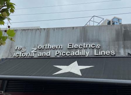
Drayton Park remained the terminus of the old GN&CR line until the connection with the main line station was finally opened in 1976. At first, the new trains serving this line were marketed as “Great Northern Electrics”. That brand has long gone, but I am always amused to see a reference (sort of) to it on the wall at Finsbury Park right where the Northern Heights platforms would have been.
From Finsbury Park it is possible to catch a train back to Moorgate from the upper platforms or a Piccadilly / Victoria line train from the lower platforms.
Links
More on the Northern Heights Plan
Walk 2 – Finsbury Park to Alexandra Palace (4.4 miles)
Walk 3 – Archway to High Barnet (8.3 miles)
Walk 4 – Finchley Central to Edgware (4.5 miles)
Walk 5 – Edgware to Elstree & Borehamwood (6.6 miles)
